|
Menu |


|
Menu |
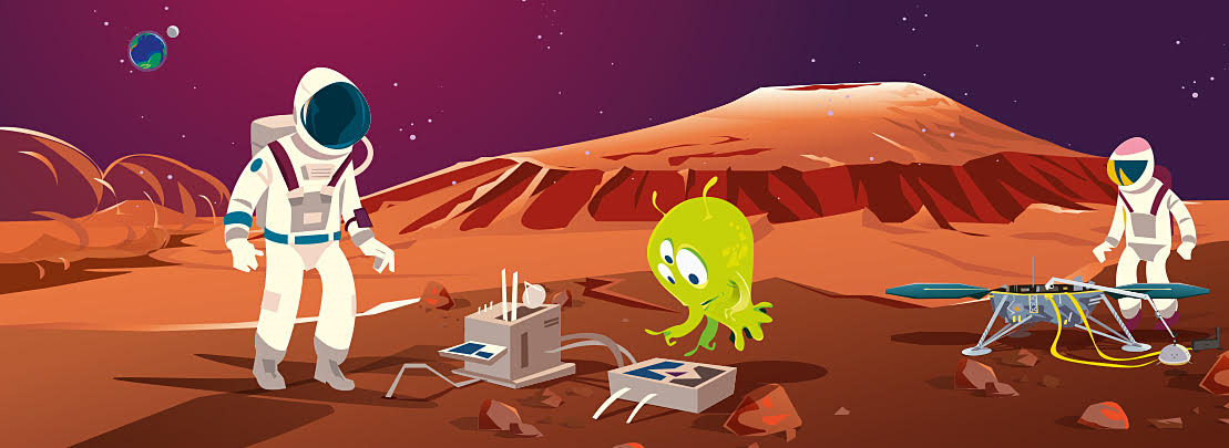
Planet Mars
| For more photos, simply follow Marsty. | |
| For more detailed information, simply follow Cosmo. |
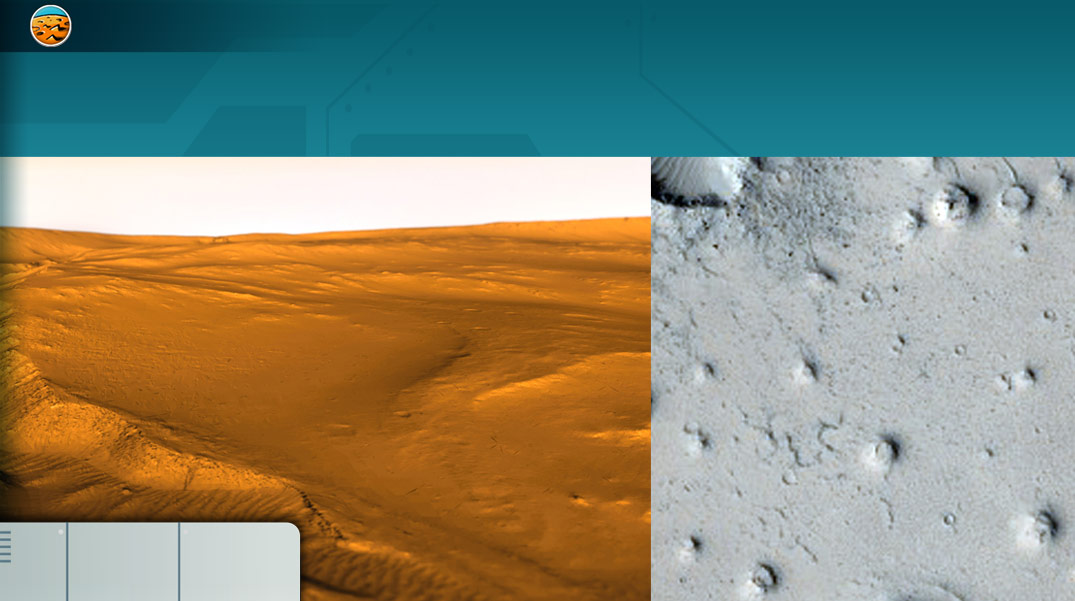
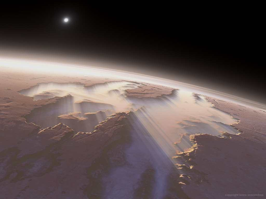
A geological walk on Mars
 Mars, a cold and arid planet
The terrestrial planets Mercury, Venus, Earth and Mars were formed more than 4.5 billion years ago from minerals and particles floating in space. However, these 4 planets then evolved in very different ways.
The reconstruction of the evolution of the planet Mars shows that at some point in its past, rivers, large lakes and perhaps even an ocean were present on its surface.
Today, Mars appears as a dessicated planet which has lost a significant part of its atmosphere.
Through this new adventure, you can investigate and try to recreate this great upheaval!
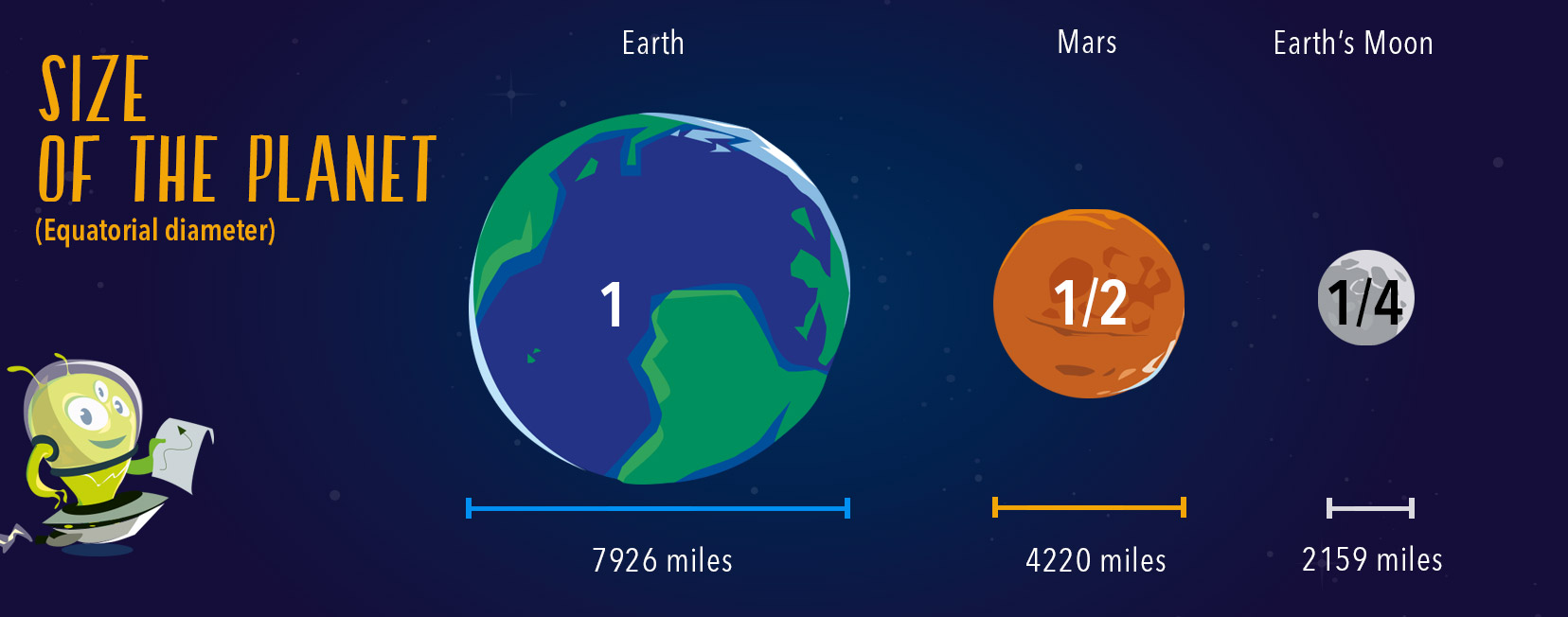
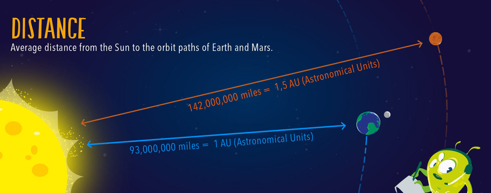
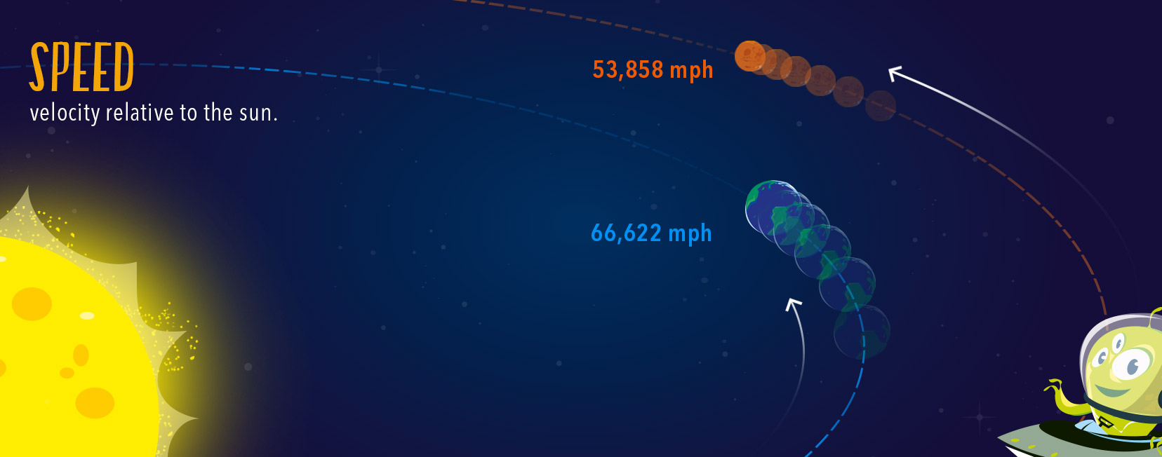
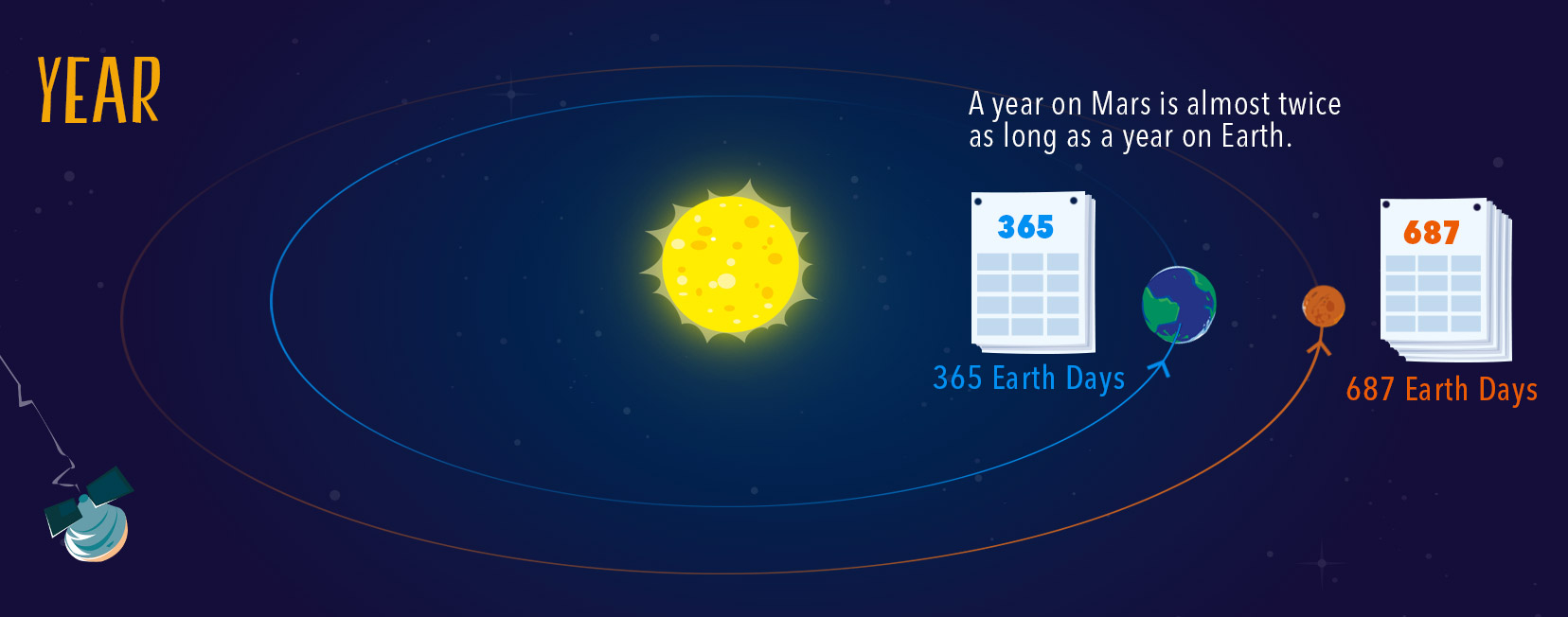
Mars is the 4th planet to orbit the Sun after Mercury, Venus and Earth. It does so at a distance of between 206.6 and 249.2 million kilometres. It is therefore 1.5 times farther from the Sun than the Earth.
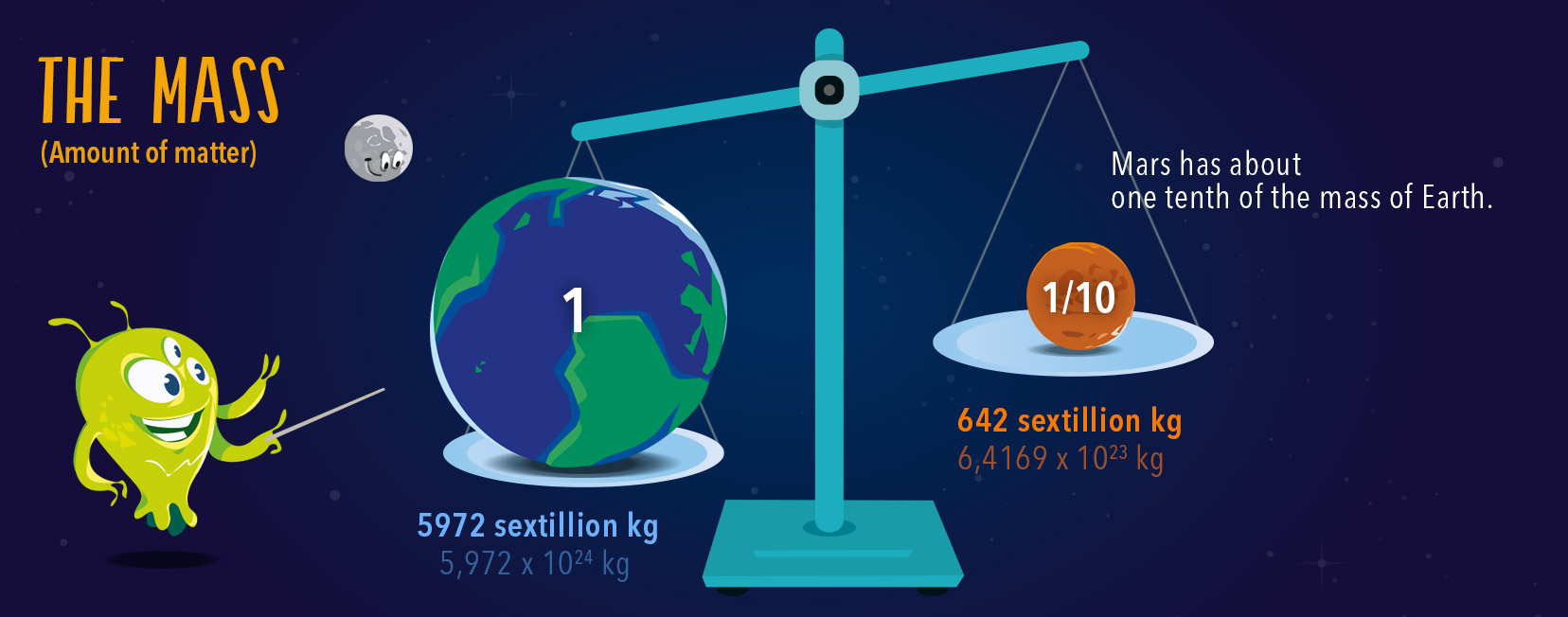
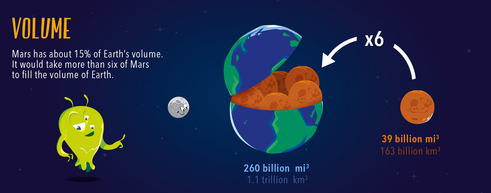
It is also 2 times smaller and 10 times less massive than the Earth.
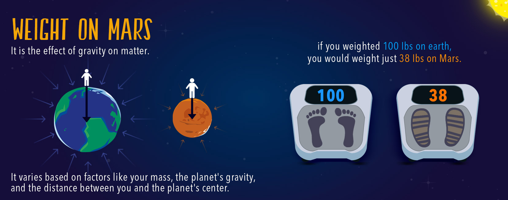
The gravity on its surface is 3 times smaller than on the surface of the Earth, and currently, Mars does not have a global magnetic field.
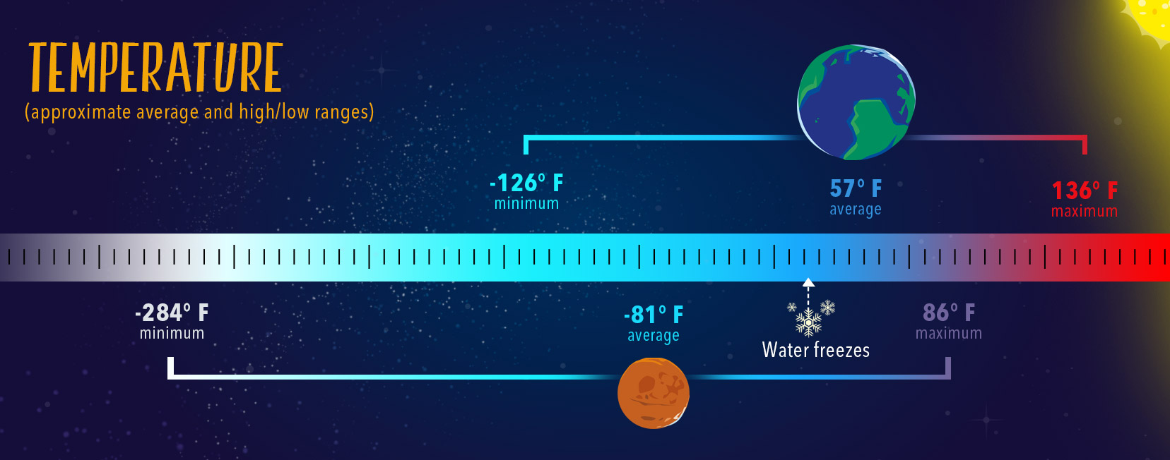
Its atmosphere is 150 times less dense than the Earth’s and consequently only generates a very small greenhouse effect. This low retention of solar radiation explains why the average temperature on Mars is about -55°C, with the lowest temperature measured at -143°C and the highest measured at +20°C.
Observed from space, Mars and Earth reveal another major difference, their colours.
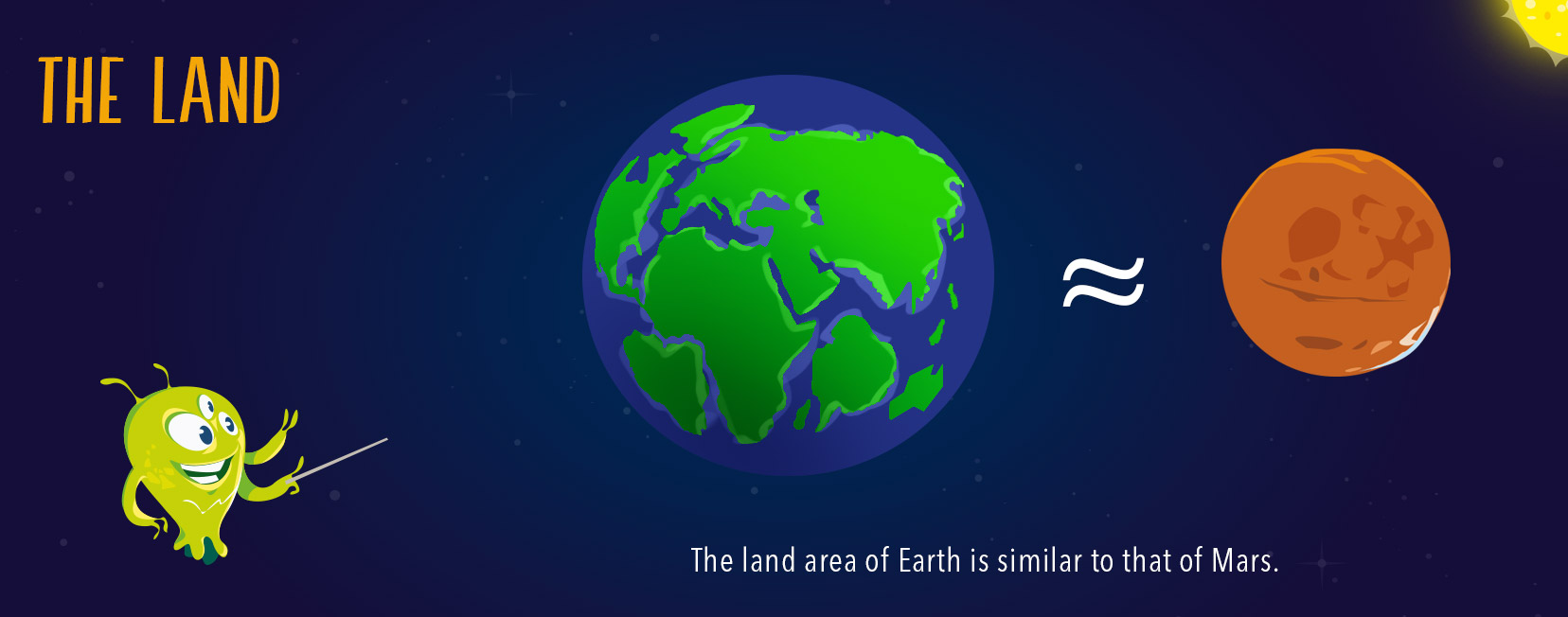
Seen from space, the Earth is a predominantly blue planet covered 70% by oceans and 30% by green continents marbled with brown.
Mars on the other hand, is a desert planet with a highly cratered surface and covered by rocks with red and ochre colours spreading as far as the eye can see.
To see a summary of the characteristics of the planet Mars, scroll through the photos below.


 Today, the surface of Mars looks like a red desert
In November 1971, Mariner 9, the first satellite to orbit Mars, mapped the entire surface of Mars with great precision.
These observations showed that the martian surface is made up of a great variety of surface features, such as meteorite craters, giant volcanoes, deep canyons, huge river valley networks, dune fields, major fault systems, polar ice caps, as well as a major morphological and topographical asymmetry between the northern and southern hemispheres of the planet.
In fact, the martian surface is marked by geology that is very different from one hemisphere to another. While the North is made up of vast plains with little cratering, the southern hemisphere is characterized by highly cratered uplands. Between these two terrains, there are two large and distinct volcanic regions.
All these observations show that Mars is a planet with a geologically active past, it used to have a global magnetic field, a thick atmosphere and large reserves of liquid water.
In the next video, you will explore the surface of Mars.
The images taken by HiRISE of the MRO space probe were colored and assembled to create a panoramic rendering of Mars (© Jan Fröjdman)
On Earth, plate tectonics are responsible for the dynamic geological processes that cause the uplift of mountain ranges, volcanic activity and earthquakes.
How can we explain how this activity stopped on Mars ?
The inability of Mars to maintain geological activity has been attributed to the absence of plate tectonics which either stopped early on in its history or maybe did not start at all. The reasons for this absence have not yet been determined, maybe it is because the small size of Mars caused its cooling to have been faster than that of the Earth, thereby preventing the start of plate tectonics.
Overview of the Atlantis Chaos region, 2000 photos are used here to create this 3D animation (© ESA)
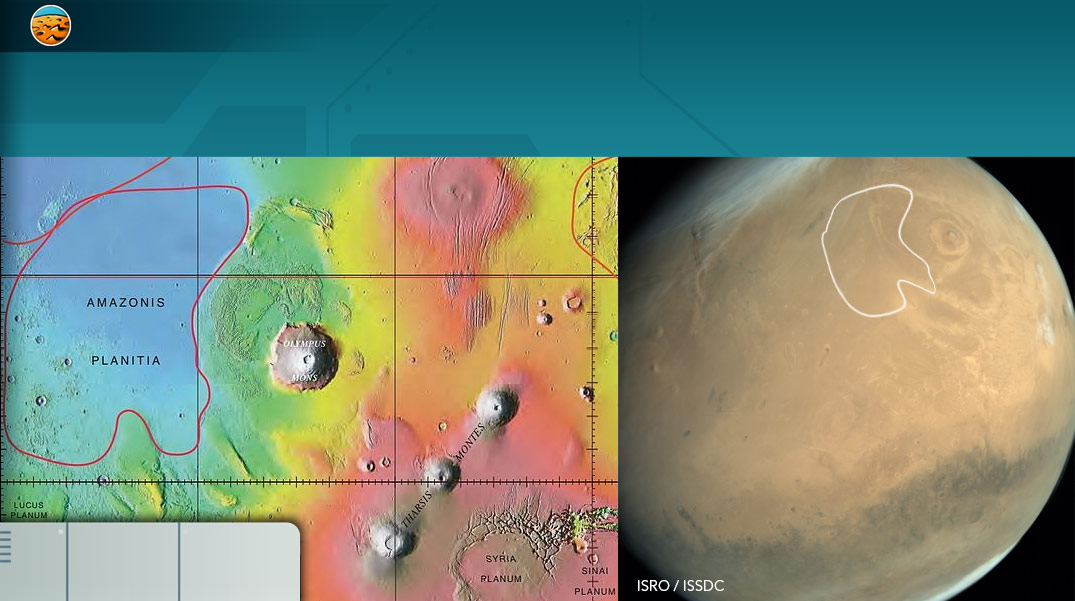
Use the map below to discover the most significant geological features on the martian surface! Click on the “switch maps” button to select either the satellite or topographic view.
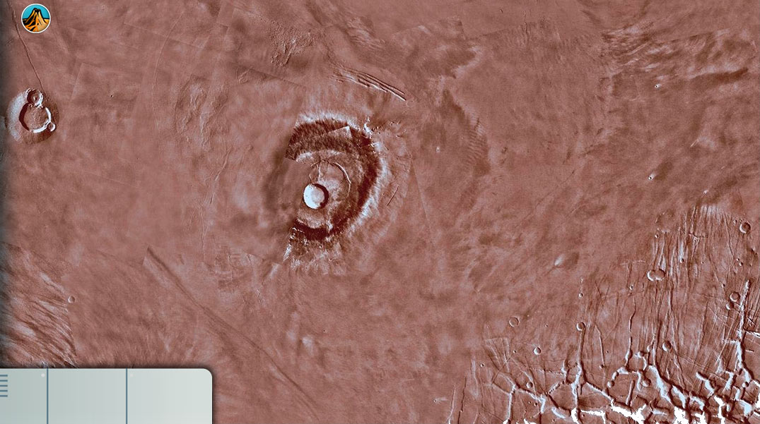
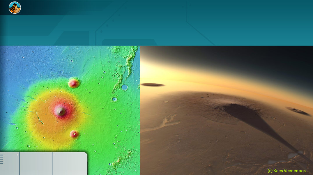
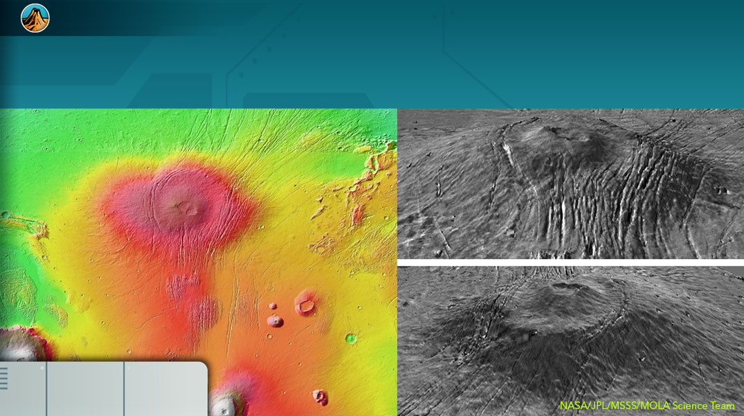
This relief is identified by Schiaparelli in the 19th century and in 1970, it is recognized as a volcano only thanks to the photos of Mariner 9.
The volcano is believed to have been formed 3.8 billion years ago.
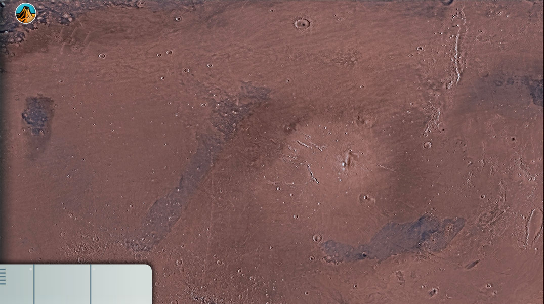
The first pictures of Amazonis planitia were taken by Mariner 4 in 1965. On this plain, many interesting geological structures can be observed.
For example: linear ridges formed around craters and Medusae Fossae created by wind erosion.
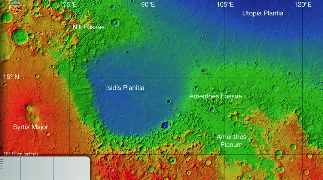
This crater and the Isidis crater are located at the opposite of the Tharsis volcanic region on the globe.
Within the basin, interesting geological structures can be observed: a mixture of fluvial, lacustrine, glacial, wind and volcanic deposits. Frequent dust storms occur in the basin.
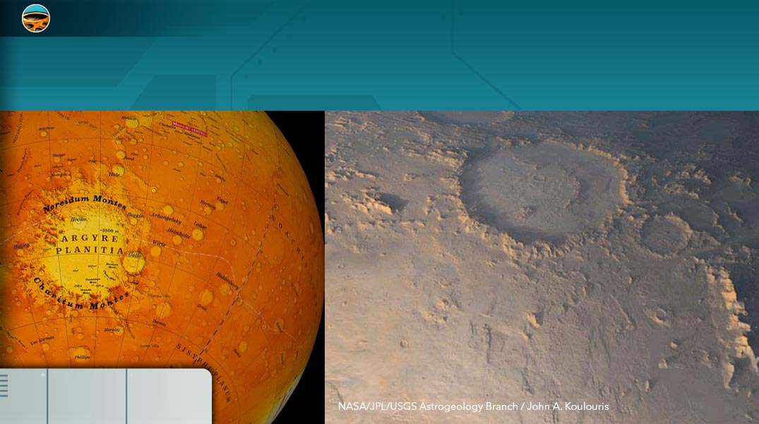
Argyre basin is the best preserved of the impact craters. It is surrounded by circular mountain ranges that were formed during the ground movement at impact.
This basin shows several signs of liquid water in the past such as ravines and alluvium.
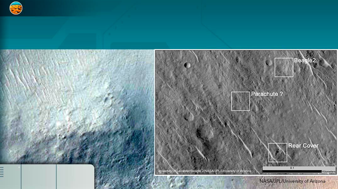
Isidis was the landing site of the Beagle 2 probe of the ESA (European Space Agency).
On the bottom of the basin, a layer of dust reflects the light and allows this crater to be visible through a telescope from the Earth.
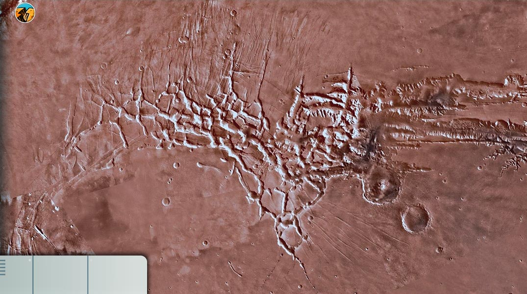
The origin of this labyrinth of rifts is similar to that of Valles Marineris. The creation of the Tharsis bulge deformed the crust causing the formation of large transverse faults.
Erosion due to water, wind, landslides, has deepened these faults.
This volcano was discovered by Mariner 9 in 1971. Due to a major dust storm covering the planet, surface details were unobservable
It is dated 3.6 billion years ago, its activity would have continued until 50 million years ago.
TThis cadeira is the widest on the planet with a width of 110 km and a height of 11 km. It formed after the final explosive eruption that emptied the magma chamber and caused the roof to collapse.
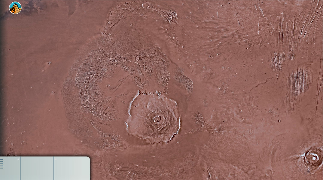
Pavonis Mons has a round caldera 100 km in diameter.
It was formed 3.5 billion years ago.
The Elysium Mons volcano is located northeast of the Elysium Planitia. Its width is difficult to estimate.
Its very fluid lava has spread over long distances. Then less effusive and more explosive eruptions formed the conical peaks, typical of stratovolcanoes observed in the region
The complex structure of the volcano shows a 3-step formation. The final phase creates the calderas system. The mass produced would have favoured the widening of the grabens of Alba and Tantalus.

Elysium Planitia is located on the border of the North/South dichotomy of the planet Mars.
It contains 4 volcanoes of a less effusive nature than those of Tharsis and have a conical shape, typical of stratovolcanoes.
The Tharsis bulge formed about 3.7 billion years ago. Tectonic activity deformed the crust and mantle forming grabens.
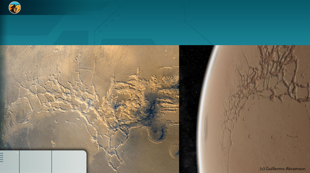
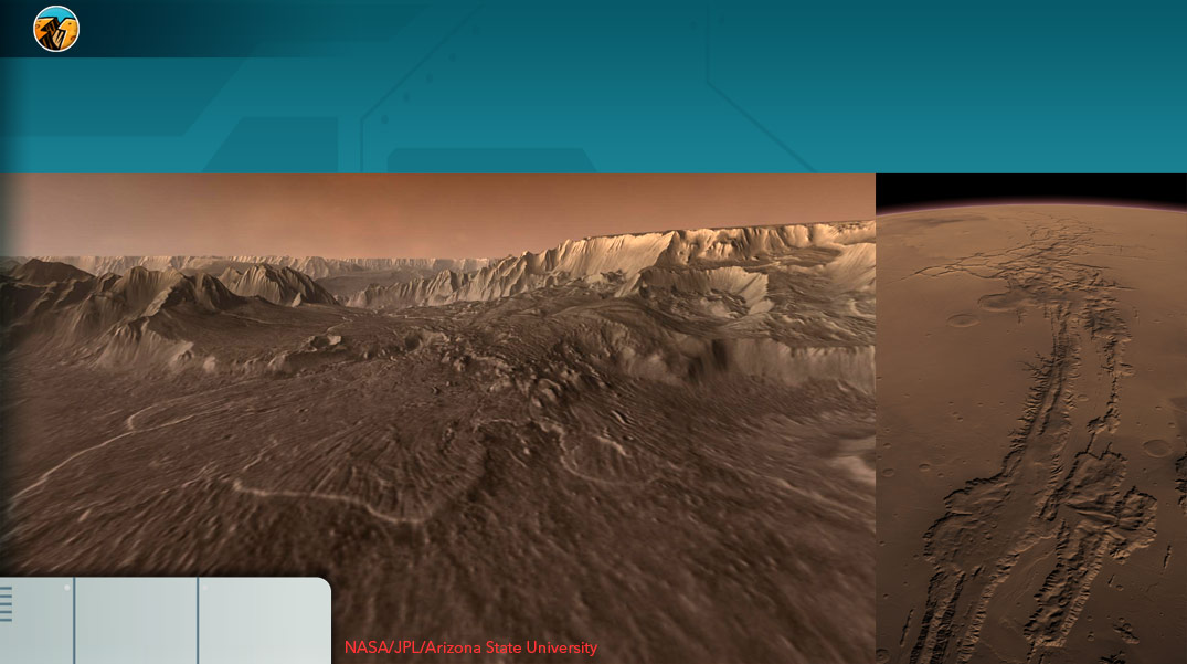
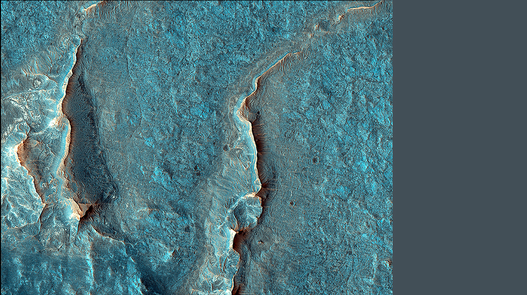
The canyons of Valles Marineris originate from the ancient tectonic activity of the planet. The strains caused by crustal deformation during the formation of the Tharsis rise caused divergent fractures.
Then, they may have been enlarged by the passage of liquid water, or by the erosion and the collapse of the rift’s walls.
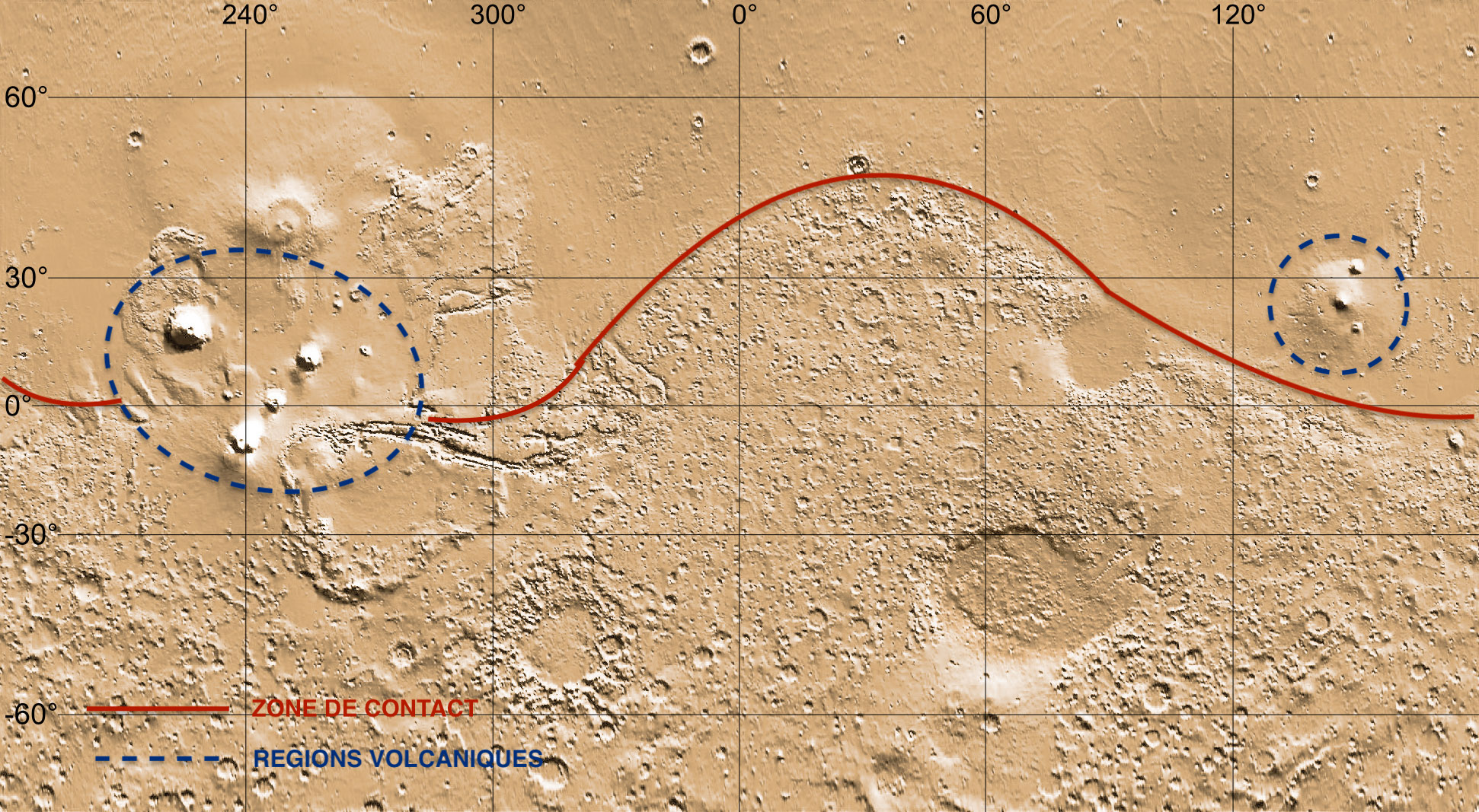
As you can see on the topographic map, the northern and southern hemispheres of Mars are very different in morphology, chemical composition and relief. These differences reflect the significant asymmetry that exists between the two hemispheres of Mars.
Planetary scientsists call this feature the Great martian Dichotomy .
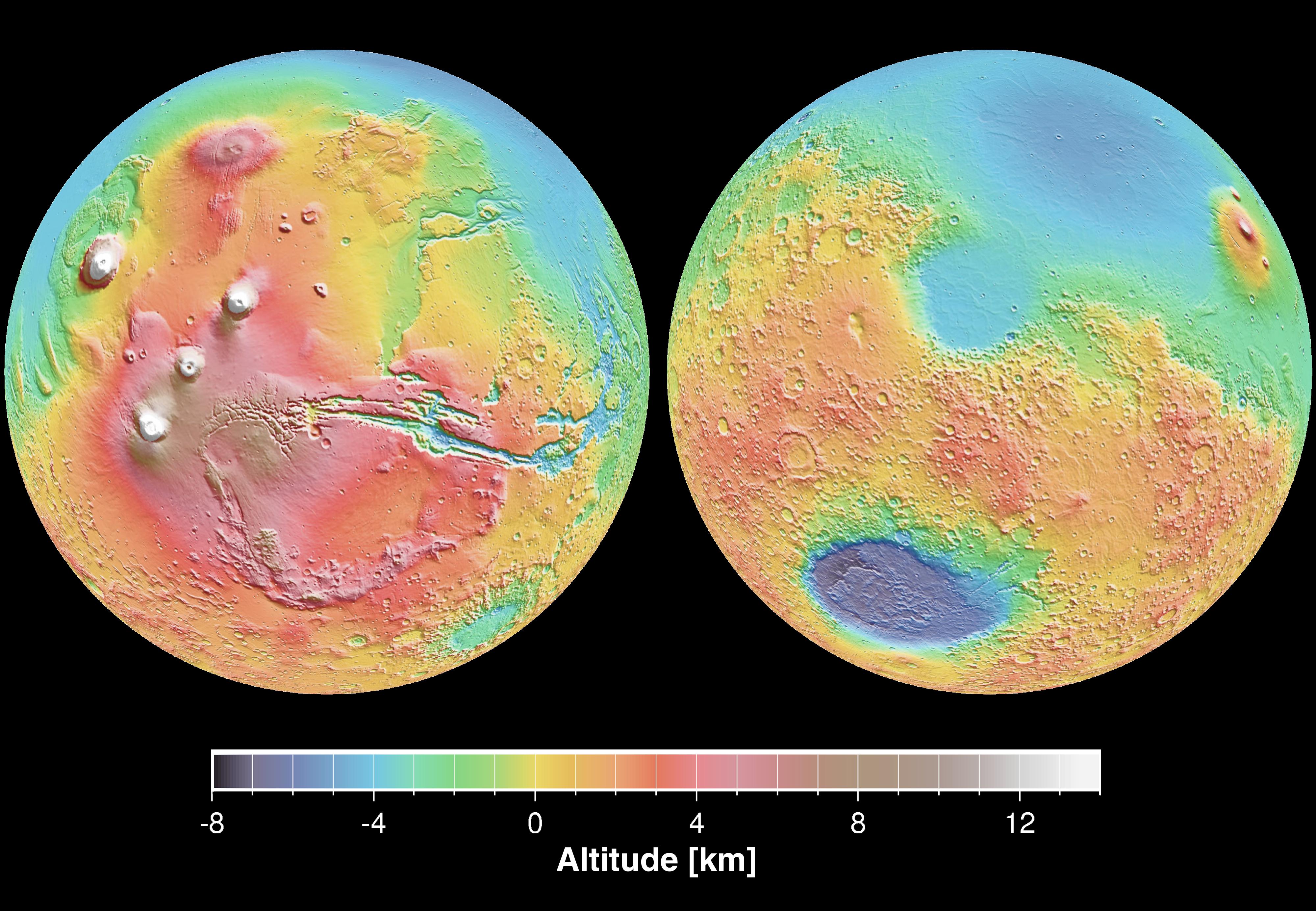
Topographical map of Mars, showing the dichotomy between the Northern and Southern Hemispheres (© NASA)
Overview of the northern hemisphere of Mars.The northern hemisphere of Mars consists of a vast plain containing relatively few meteorite craters. This area covers almost a third of the surface of Mars!
This great plain is called Vastitas Borealis . It includes the expanses of Arcadia, Amazonis, Acidalia and Utopia.
In this region, the martian crust is almost uniform and has a thickness of about 35km. The oldest surfaces are 3.2 billion years old while the most recent volcanic eruptions are believed to have happened only a few million years ago.
If you go to the google site https://www.google.com/mars/ you can see a detailed map of Mars.
The chemical composition of these surfaces corresponds to andesites, volcanic rocks found in the mantle that reach the surface during volcanic eruptions.
At the North Pole is an immense plain called Vastitas Borealis (© NASA)
The lack of much topographical relief in this area might be evidence for the existence of sedimentary processes in the past on Mars. Many geologists believe that an ancient ocean, Oceanus Borealis, once covered much of this northern hemisphere.
The video below is an artist’s model of the transition from wet to dry Mars (© NASA/MAVEN/Lunar and Planetary Institute).
Artistic interpretation of the transition from wet to dry Mars (© NASA/MAVEN/Lunar and Planetary Institute)
The boundary between the North and the South.The 2 hemispheres of Mars are remarkably different and the boundary between them has lots of geological features.
Along this boundary there is a huge escarpment, several kilometers high. This striking geological boundary takes on different forms depending on its location: a steep cliff, plateaus with asymmetric slopes, called cuesta, hilly terrain or landscapes covered with large flat-topped hills and steep slopes, called mesa.
You can see these mesa features in the photo below
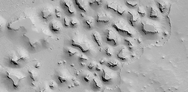
Mesa landforms on Mars (© NASA)
This boundary, all along the contact zone between the northern and southern hemispheres, indicates that a catastrophic event occurred on Mars.
Contact zone of the martian dichotomy (© NASA)
Overview of the southern hemisphere of Mars.The southern hemisphere is made of ancient terranes dating back to the formation of the planet, that is between 4.6 and 3.5 billion years ago.
These terraness are high plateaus covered by countless impact craters, formed during meteorite bombardments that began between 4.1 and 3.8 billion years ago. They represent about 60% of the martian surface.
This part of Mars is very rich in basalts, volcanic rocks coming from the mantle.
Going to the google site https://www.google.com/mars/ it is possible to see the detailed map of Mars.
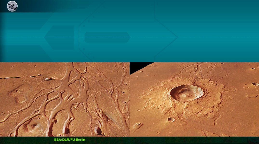
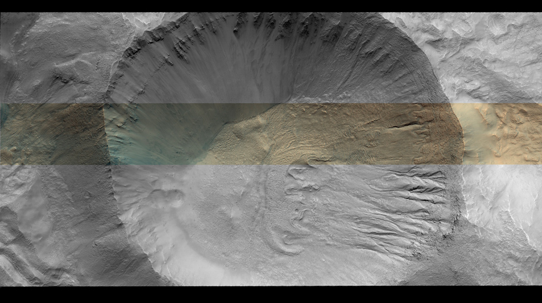
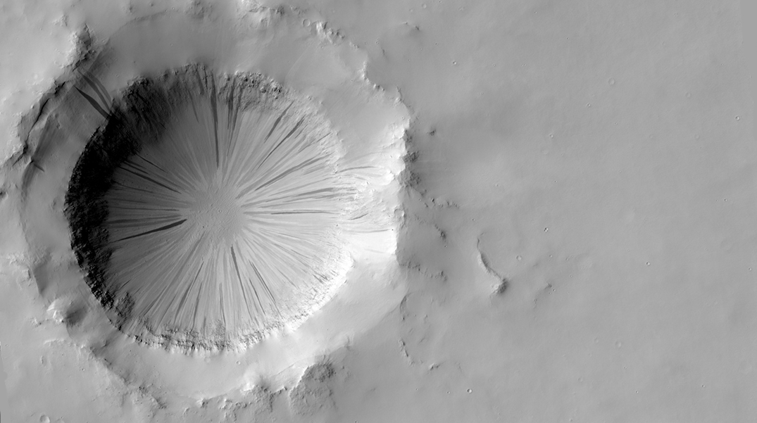
Below is an example of meteorite impact craters on Mars. The largest crater on the photo, Schiaparelli, is at the equator.
Schiaparelli Crater, a meteorite impact(© NASA)
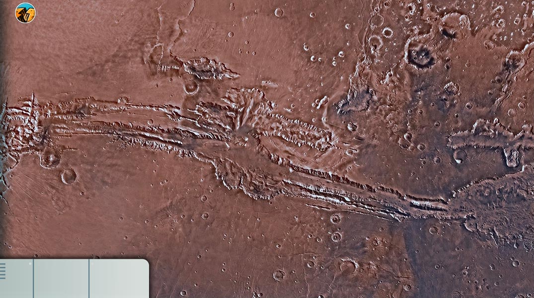
It is also in the southern hemisphere of Mars that the longest canyon in the solar system is located,, Valles Marineris.
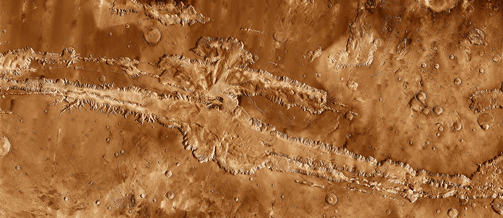
Valles Marineris, the longest canyon in the Solar System, mapped by the 2001 probe Mars Odyssey (© NASA/JPL)
Valles Marineris, mapped by the 2001 Mars Odyssey probe (© NASA/JPL)
The southern hemisphere also has basins, which resulted from the impact of large bodies, greater than 100km in diameter, with the martian surface. For example, the Argyre Basin is 600km in diameter, or the huge Hellas impact basin, whose base is 9km below the average level of the surface, making it the lowest point of Mars.
The two volcanic regions of MarsBetween the northern and southern hemispheres, there are 2 distinct volcanic regions: the Tharsis Dome and the Elysium Planitia.
In the heart of Mars (© CNES,Team SEIS)
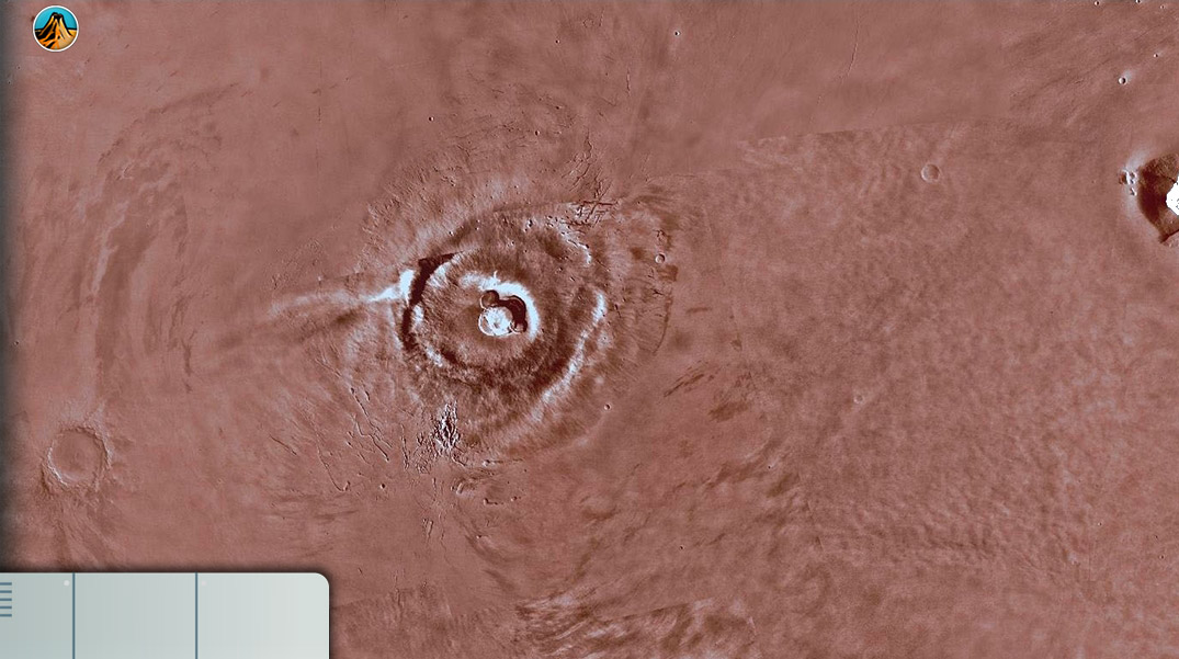
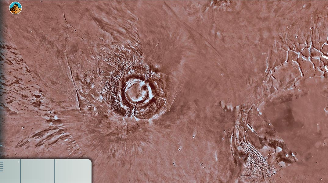
Let’s first explore the Tharsis Dome region: Tharsis Montes (on the map)
The most imposing martian volcanic system, the Tharsis Dome, is a vast volcanic uprising about 5,500km in diameter and rising 4 to 8 km above the Mars reference level.
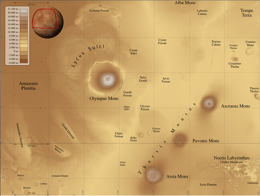
Map of Olympus Mons and Tharsis Montes on Mars (© NASA)
This dome contains many of the largest martian volcanoes, including those with a caldera. A caldera is a giant volcanic crater that can be several kilometers in diameter. Its outline is either circular or elliptical. The name comes from the Portuguese word meaning “cauldron”.
Formation of calderas: These geological structures appear due to the collapse of the central part of a volcano, usually because of the collapse of a subterranean magma chamber which has emptied during an eruption.
Tharsis Montes (© NASA)
The main volcanoes are:
Alba Mons , with a width of 1600km and a height of 6.60km
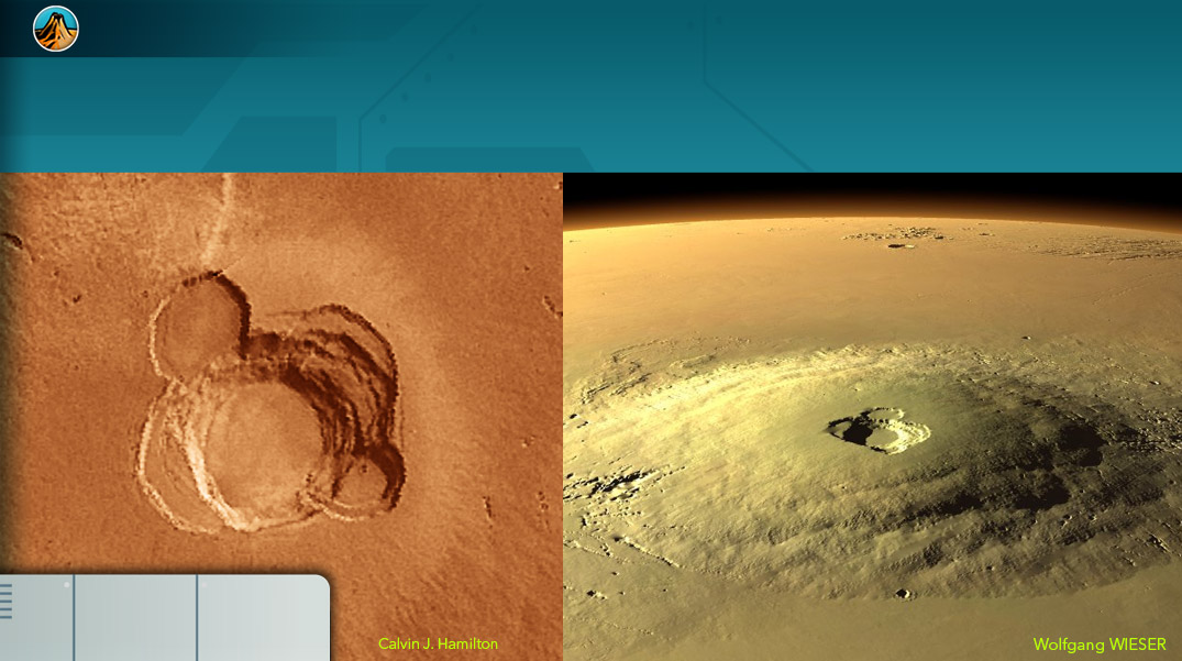
Arsia Mons , a shield volcano about 435km in diameter and 9km high, with a huge caldera 110km in diameter and 16km deep.
Biblis Tholus , 170km long by 100km wide and 3km high, with a caldera 53km in diameter and 4.50km deep.
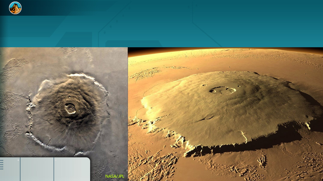
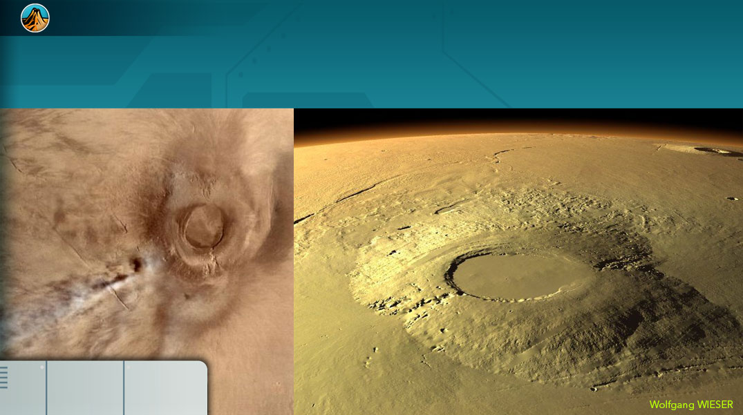
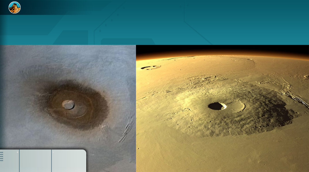
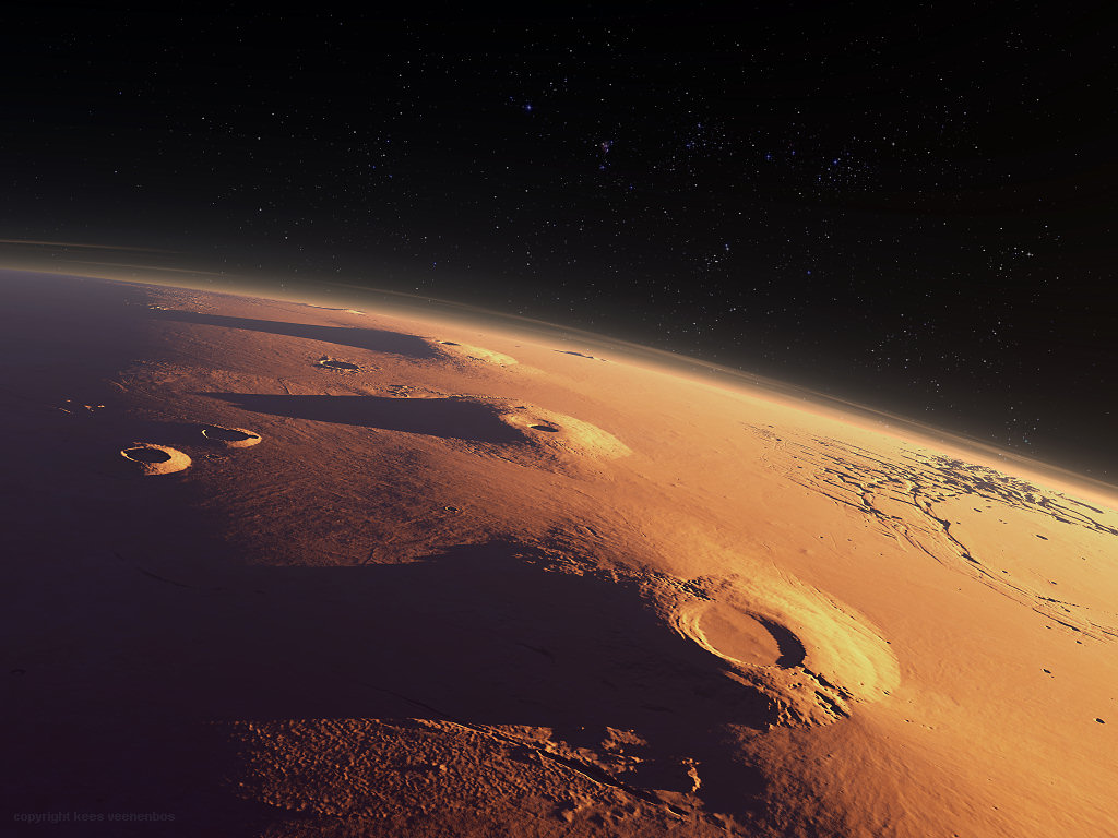
Olympus Mons, the biggest volcano listed in the solar system. It is just west of the Dome and is often associated with it. It has a diameter of 600km and a height of 27km, its caldera is about 90km in diameter. The most recent lava flows date back only a few million years, the largest have flow rates estimated to exceed one million cubic meters per second. Olympus Mons formed 2.5 billion years ago and would have remained active for about 2 billion years.
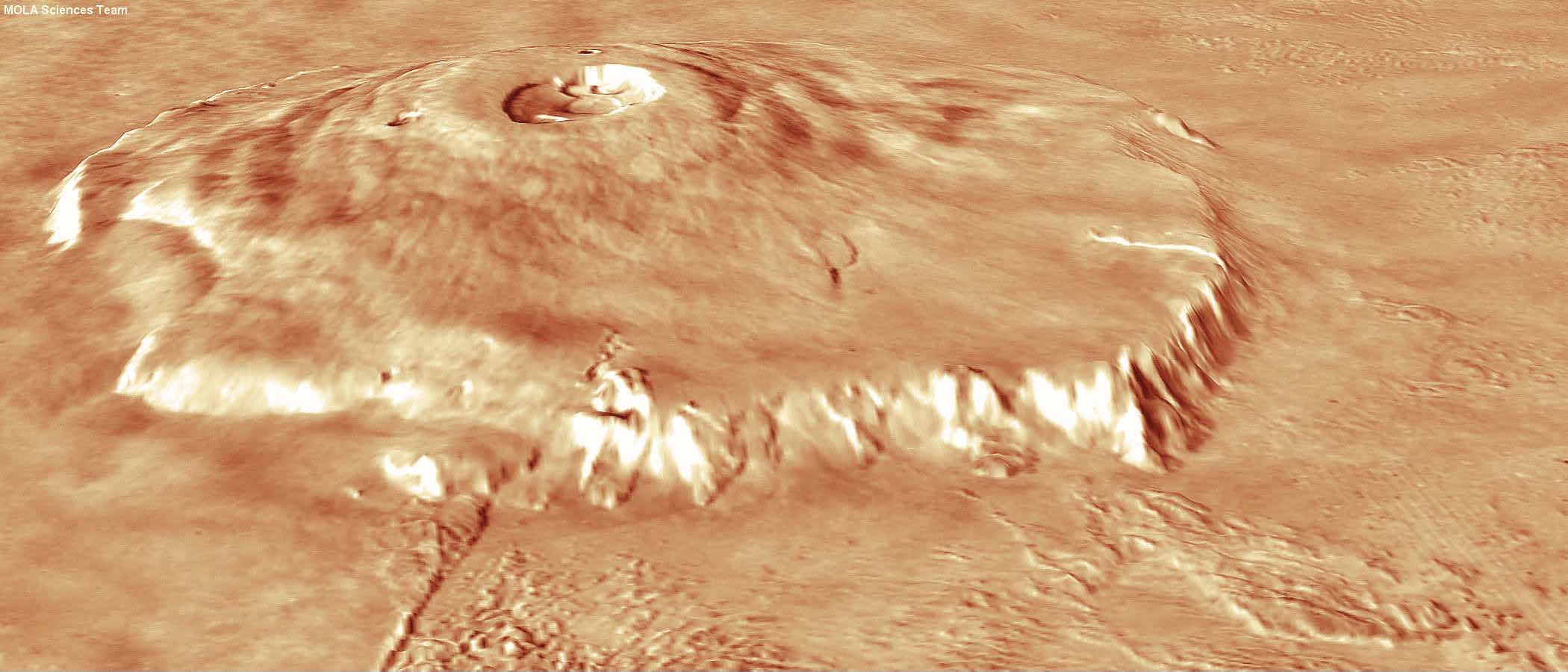
3D reconstruction of the Olympus Mons volcano from Mars Global Surveyor data (© NASA)
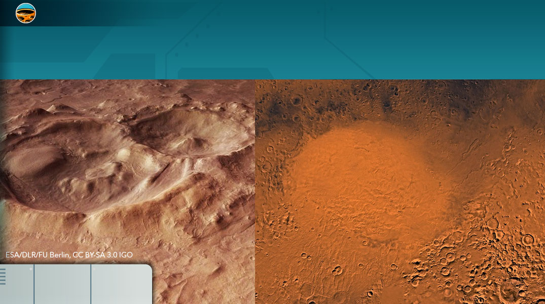
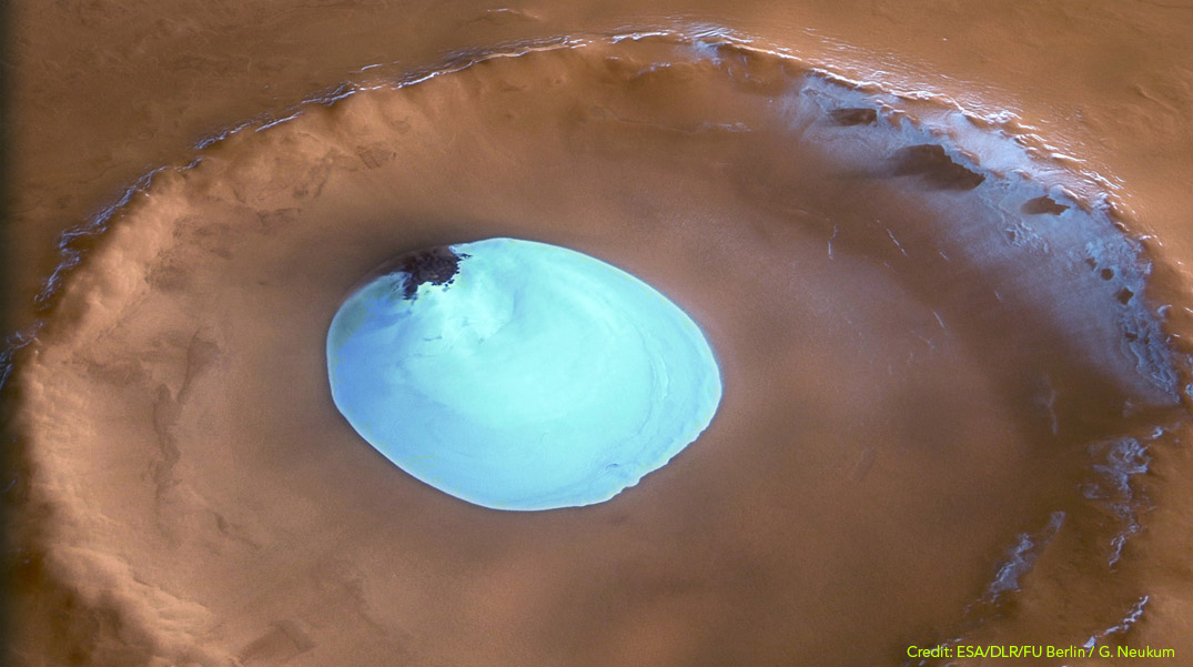
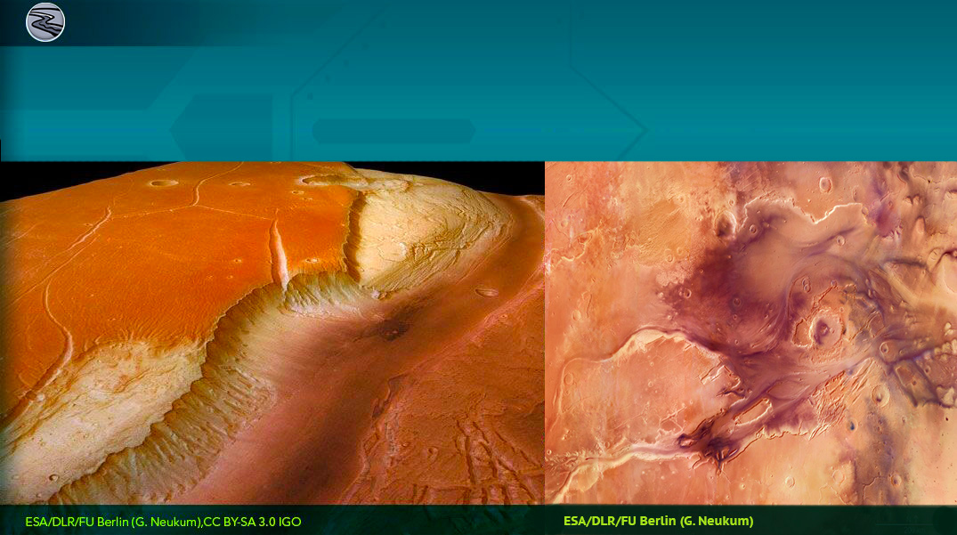
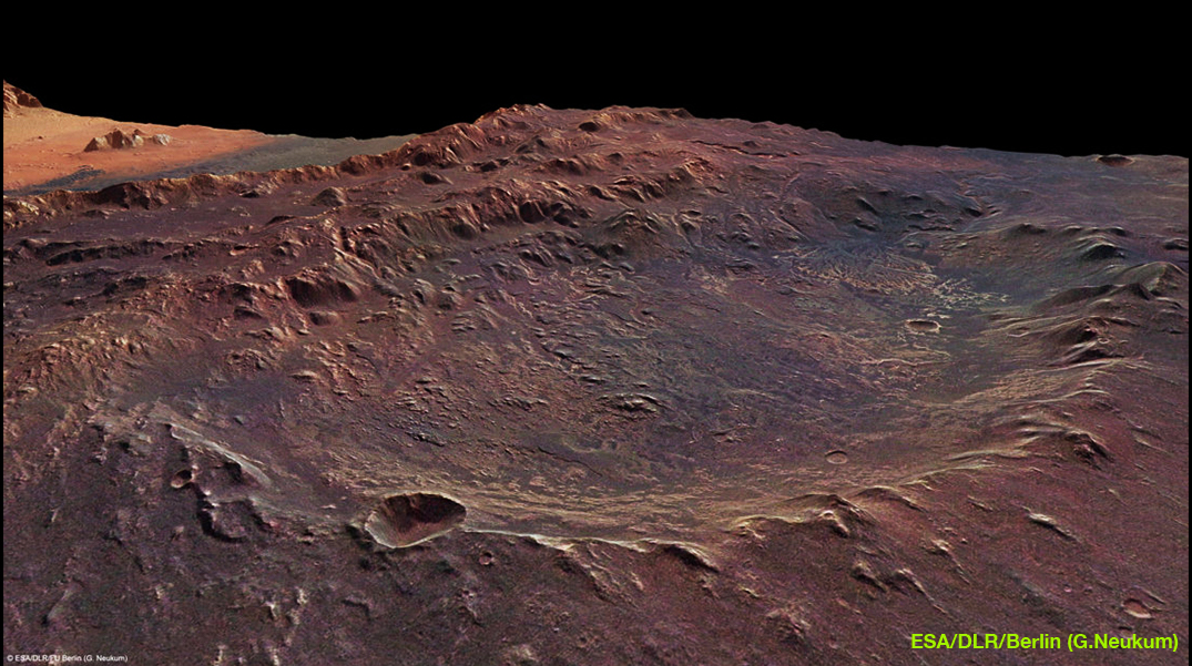
Elysium Planitia
Similar to the Tharsis Dome, but located on the equator, the Elysium Planitia area also features giant volcanoes.
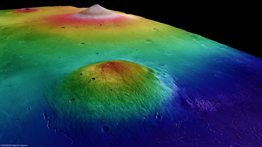
The volcanoes of the Elysium Planitia (© ESA/DLR/FU Berlin (G. Neukum))
These giant volcanoes are:
Apollinaris Mons and Albor Tholus are stratovolcanoes, covering an area of 296 km in diameter and comprising several calderas. The first caldera has a diameter of 80 km and a depth of 5 km. The second caldera has a diameter of 160 km and a depth of 4 km and the last caldera has a diameter of 30 km and a depth of 3 km.
Elysium Mons rises 13 km above the surrounding plains and is about 240 km wide, with a small circular crater 14 km in diameter.
Hecates Tholus, has a crater 10 km in diameter at 5 km altitude.
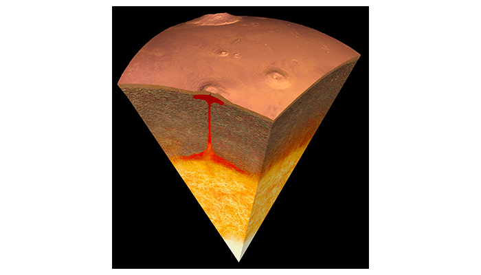
Why are there giant volcanoes on the surface of Mars?Since gravity is 3 times lower on Mars than on Earth, it allows mountains to rise much higher. However, the main reason for the giant volcanoes is probably the lack of plates tectonics on Mars.
Volcanism on Mars is the result of a magma surge that penetrated the crust and caused very low viscosity basaltic lava flows. Over time, they stacked up in layers. The volcanoes formed this way are very wide and relatively flat with flanks sloping at angles less than 5 degrees. The enormous magma chamber that fed Olympus Mons would be about 80 km in diameter and maybe 10 to 15 km deep in the martian mantle.
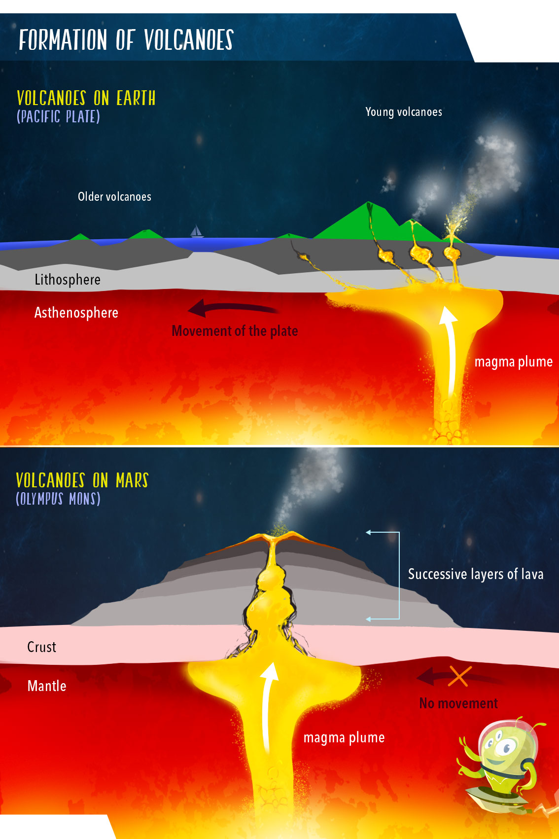
Comparison of the formation of a volcano on Mars and from a hot spot on the surface of Earth.(© Arteclick)
In comparison, on Earth, volcanoes are often the result of a hot spot in the mantle. These points remain fixed while the tectonic plate moves over them. As a result these volcanoes do not have time to pile up in successive layers of lava flows. Volcanoes are active when they are above the magma chamber and they die out as soon as the plate tectonics have moved them away from the magma chamber.
One example is the chain of Hawaiian volcanic islands. These islands line up as a result from the slow, continuous north-westerly movement of the Pacific Plate over a fixed hot spot.
How Did Mars Get Such Enormous Mountains? (© NASA-JPL)
The chemical composition of the surface of Mars.Mars appears red to us because of the prevalance of iron oxide at its surface.
Martian soil has magnetic properties (1 to 7% magnetite), which gives it the properties of wet sand while it is dry. Magnetite is produced by the oxidation of a material derived from basalt.
Is Mars really red? (© NASA/JPL)
Although there is still much to learn about martian rocks, samples from martian meteorites and rovers sent to the surface have allowed for a variety of tests. To obtain samples for analysis, the rovers first remove the first layer of rock that may have been altered by the elements and then perform their measurements.
Below is an animation of the Opportunity rover that shows you this process.
To obtain samples for analysis, the rovers first remove the first layer of rock that may have been altered and then they take measurements with their sensors. (© NASA)
Among the rovers that provided us with information on the martian surface, Opportunity holds the record for longevity.
Scheduled for a three-month mission, Opportunity withstood the harsh environment of Mars for 14 years!
However, deprived of sunlight due to a dust storm in June 2018, it stopped and the mission officially ended on 13 February 2019.
In the following video, find out what Opportunity taught us.
Opportunity on Mars: an exceptional journey (© Le Monde)
Today, apart from the InSight probe which recently arrived, Curiosity is the only active rover on Mars. It continues moving slowly towards Midland Valley after successfully climbing Aeolis Mons, taking rock samples for analysis along the way
By early December 2016, Curiosity has travelled 15 kilometres since its landing in August 2012 in Gale Crater, near the base of Mount Sharp. It has already climbed 165 metres in altitude.
So what did it find ?
The graph below shows the distance travelled and the altitudes at which it took samples of rock powder and analyzed them with its CheMin instrument. These 10 samples are shown in the figure below by 10 pie charts.
These charts are colour coded to represent the different mineralogical constituents of the 10 clay samples that were analyzed. The mineralogical variations of these clays are due to differences in one or the other of the following factors: How the materials were deposited by the water that entered the lakes, variations in the processes of sedimentation and rock formation and finally how the rocks have been modified since deposition.
The different chemical composition of these clays highlight the presence of water on Mars.
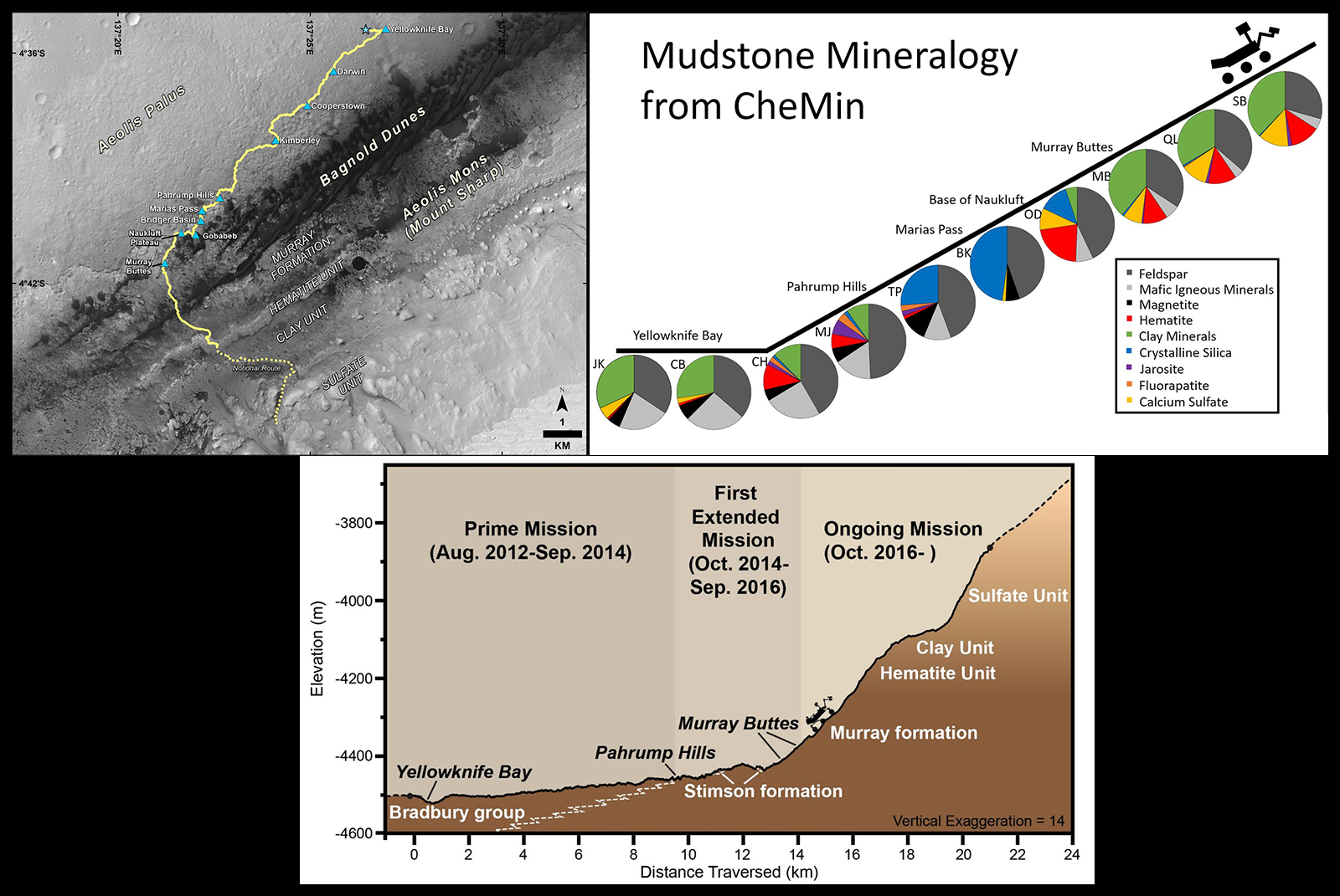
In these images, you can see the route taken by Curiosity on Aeolis Mons. Variations in mineralogy and soil composition are observed along this route. (© NASA/JPL-Caltech/Univ. of Arizona)
Based on this analysis, it appears that the martian crust consists mainly of volcanic rocks of the type andesite and weathered basalt.
Basalts and andesites are the 2 most common terrestrial rocks, which proves that these two planets have experienced similar volcanism.
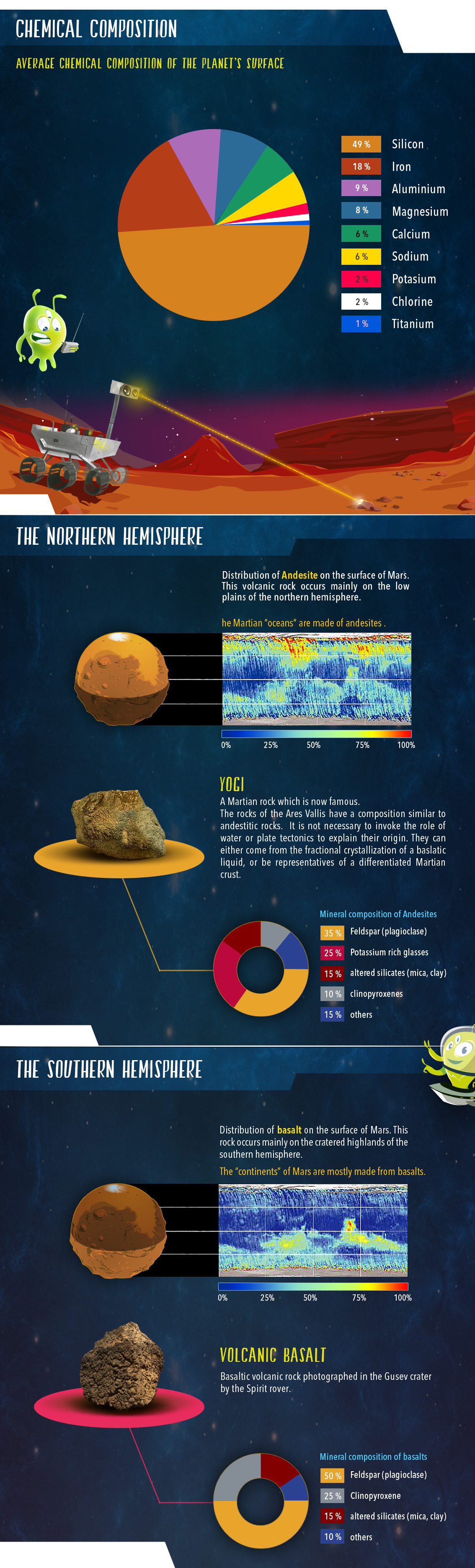
Average chemical composition of the surface of Mars, in rocks from the northern hemisphere and in rocks from the southern hemisphere (© Arteclick).
Martian volcanism, once very active, played a fundamental role in the formation of the crust. The basalts that make up most of the crust are rich in iron. This has favoured the formation of minerals such as hematite and magnetite.
Hematite is composed of iron and oxygen, giving Mars its characteristic red hue.
Grey hematite is a good indicator of the presence of water because it is generally formed in an aqueous medium and accumulates in layers at the bottom of lakes. However, this mineral can also be formed by volcanic activity. The rovers sent to Mars have detected high concentrations of this mineral near the planet’s equator.
The hematite grains found are rounded and cemented together by the action of liquid water. This is therefore the first mineral evidence of the presence of water in Mars’ past.
On Earth, hematite is often accompanied by clays and carbonates. The presence of sulphates is also common in some terrestrial sediments formed in water.
Clay and sulphates are also present on the surface of Mars.
By combining this data with that collected by the Spirit rover in 2010, it is possible to identify the presence of magnesium and iron carbonates on the surface of Mars!
Because these carbonates dissolve in the presence of acids, it seems that a low-acid aqueous environment, favorable to life, must have once existed on Mars!
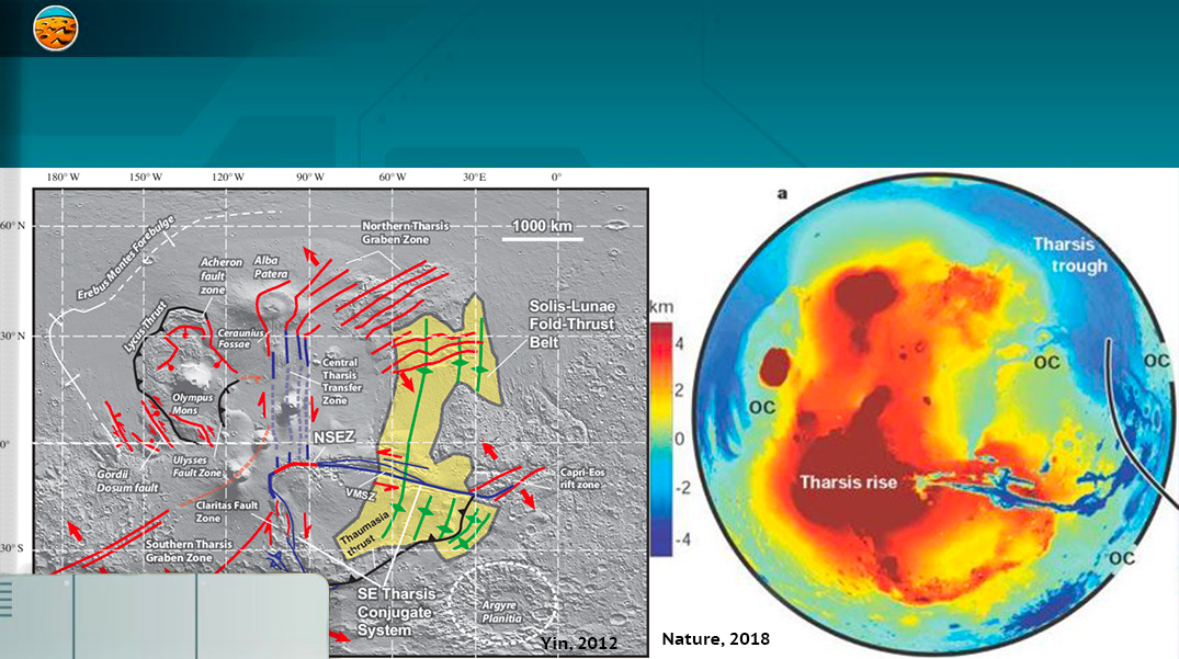
Topography, Gravity and Crustal thicknessThe study of a planet’s gravitational field provides limits on its possible internal structure. NASA researchers have launched satellites into orbit around Mars that measure its gravitational field and have estimated the thickness of its crust by combining this data with laser altimetry, which provides accurate topography.
From left to right, maps of the topography, gravity field and thickness of the Mars crust (© NASA/GSFC/Scientific Visualization Studio)
What can we learn from these studies?
Estimates of the nature and thickness of the martian crust provide information on its topography and mineralogy. They show that there is once again a significant contrast between the northern and southern hemispheres.
In the north, the relief is low and the crust thin, reflecting the presence of an ancient ocean. The rocks that form this crust are andesites. This is surprising! because on Earth andesites make up the continents!
In the south, the relief is high and the thickness of the crust is significant, indicating the existence of a continent. The rocks that form this crust are basalts. This result is as surprising as the previous one because on Earth basalts make up the bottom of the oceans!
To summarise, the martian “continents” are made of basalts while the martian “oceans” are made of andesites. This is the opposite of what is observed on the surface of the Earth!
To try to understand these observations, it is necessary to compare the formation processes between Earth and Mars. It is with this objective that the SEIS seismometer is installed on the surface of Mars.
Installation of the SEIS seismometer by the InSight mission on the surface of Mars will allow seismic measurements which can help scientists to determine the nature of the crust,mantle and core of Mars. Is it liquid? Solid? Or in the process of crystallization ?
What is the origin of the martian Dichotomy?Scientists have proposed different hypotheses to explain the origin of all these differences between the northern and southern hemispheres of Mars.
To date, they agree that only a major cataclysm would have been able to modify the altitude and relief of half the planet !
The Martian Dichotomy(© Arteclick).
Two hypotheses are put forward to understand the origin of this asymmetry.
The first hypothesis involves a huge collision with a proto-planet with a diameter of about 1000 km. When this proto-planet crashed into the northern hemisphere of Mars kilometres of crust were vaporized in space. The intense heat released by the shock liquefied part of the crust and faults opened. Molten magma rose up in large quantities, spreading onto the surface and erasing the footprints of older impacts. In the end, the impact reshaped the whole region by thinning the crust and lowering the average altitude of the northern hemisphere by several kilometres in an instant.
The second hypothesis is based on an internal phenomenon specific to Mars. If, at the time of the appearance of the Dichotomy, the mantle of Mars was heterogeneous, localized convection movements or a huge plume of molten material could have caused a crustal depression in the northern hemisphere and released gigantic floods of lava erasing the old surface and its impact craters.
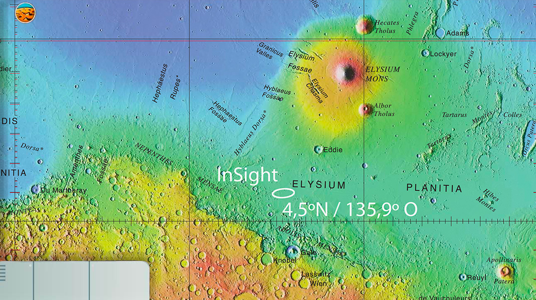
The landing area of InSight, bordering this asymmetry, allows the SEIS seismometer and the HP3 thermal probe to collect data that will allow scientists to discover the secret of this Martian Dichotomy !
Quiz!
Validate your knowledge!
Formation of Mars and Earth
 Comparative evolution of Mars and Earth, based on current knowledge.
In this step, we will compare the evolutionary history of Mars and Earth. This rocky planets are both made of volcanic materials. Each experienced a major disaster at the start of their formation, however, their subsequent development was very different. What is the reason for this divergence? Is it the small size of Mars? Or maybe a lack of water at the start of its evolution?
To try to answer this question, let us first examine the major stages of the Earth’s evolution from the beginning of its formation 4.55 billion years ago until -1.6 billion years ago when a supercontinent called “Columbia” formed on its surface.
Then let’s try to find out what happened to the planet Mars. How far back in time can we go on Mars?
Discover the differences in the evolution of Mars and Earth according to current knowledge.


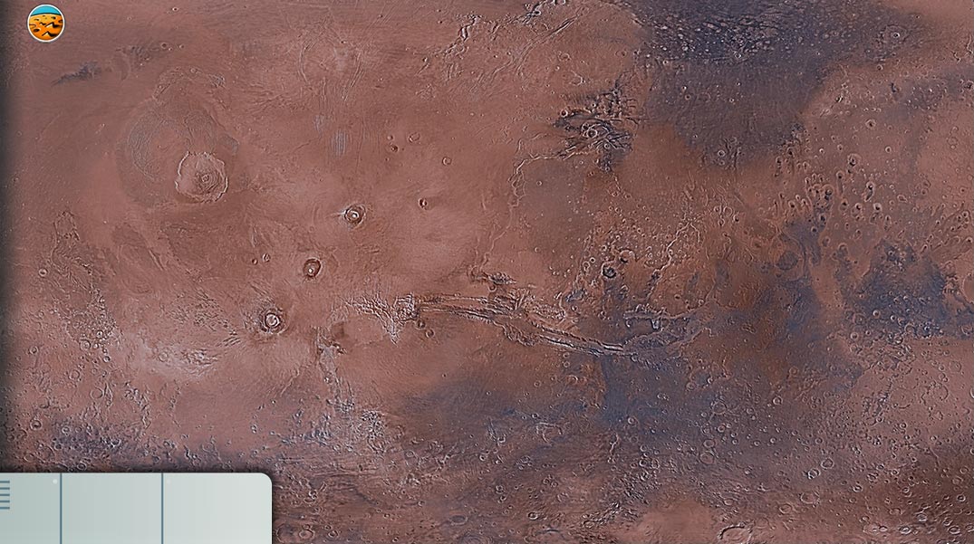
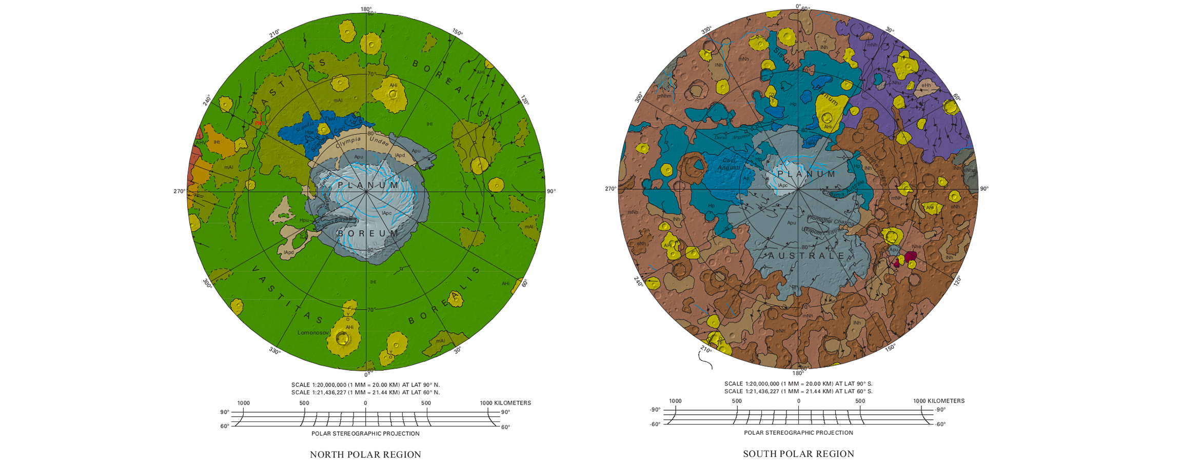
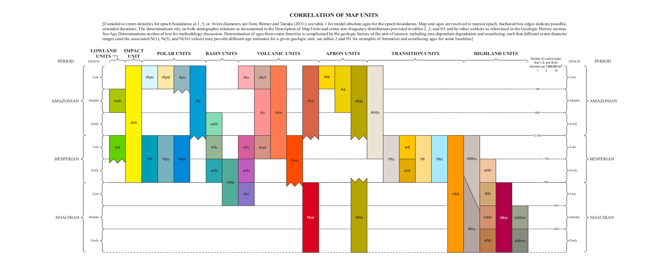
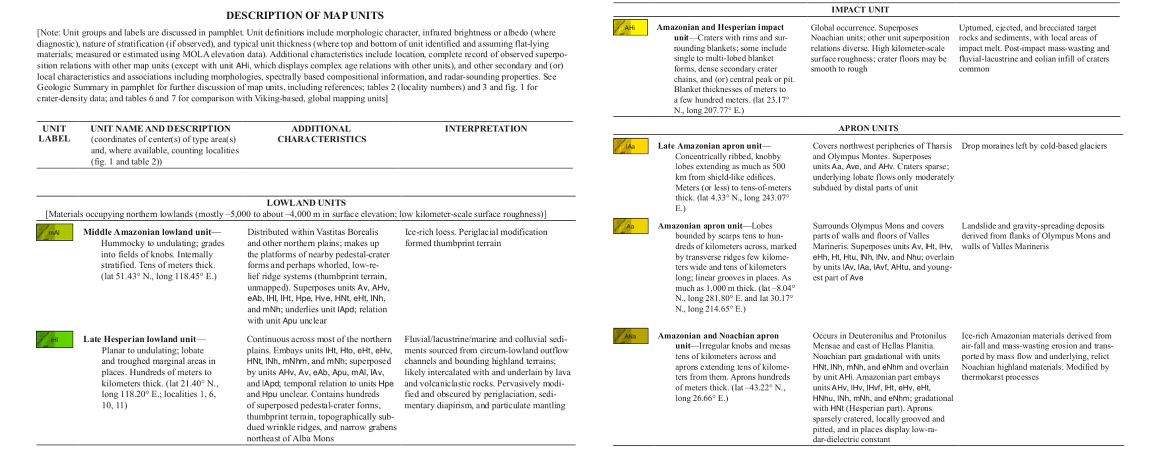
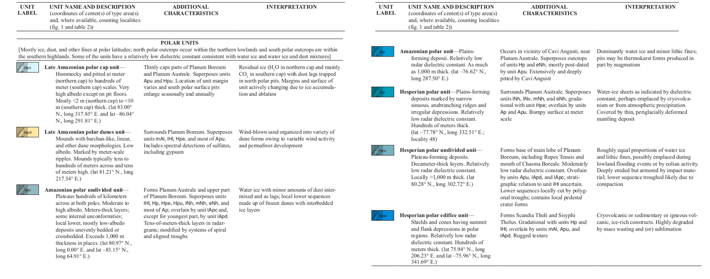
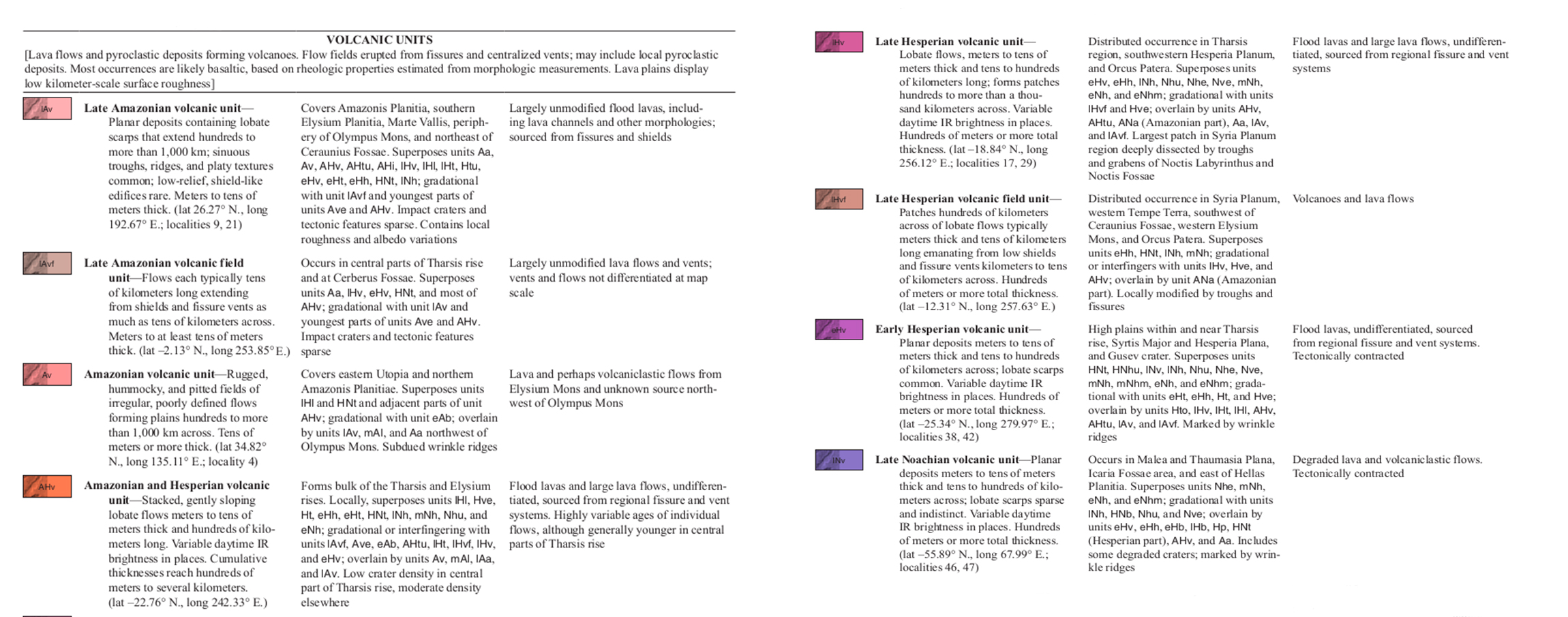
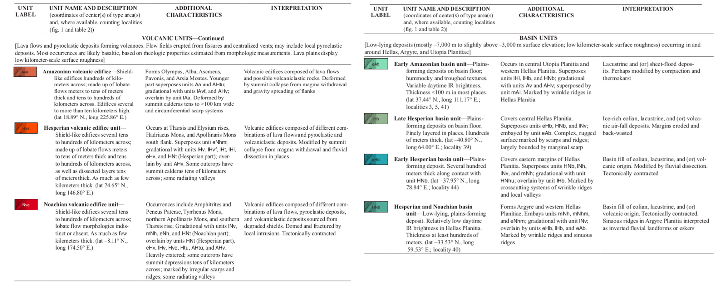
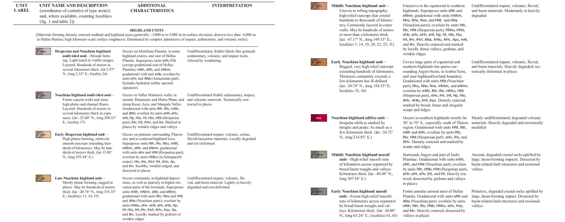
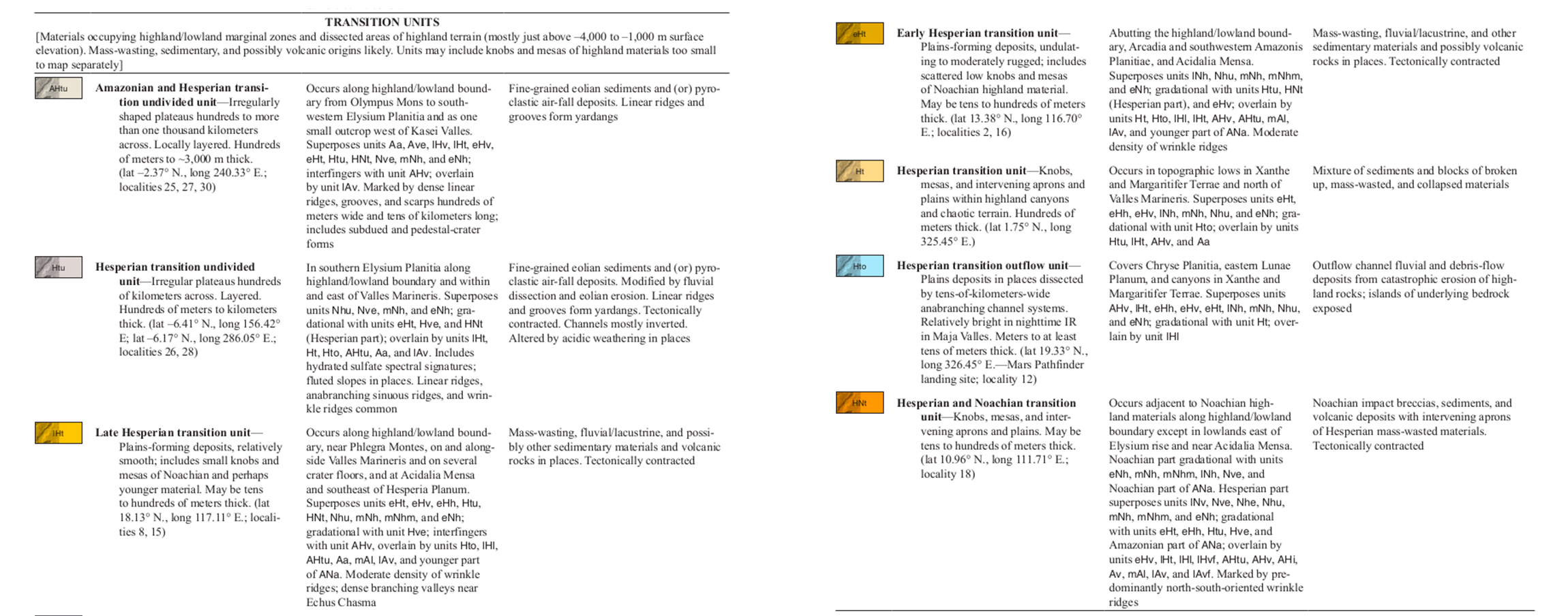
 Geologic Map of Mars
The geology of Mars reveals the history of the formation of the Martian crust.
All the different coloured parts represent areas of crust that were formed at different times and from different processes. For example, the extensive green area near the north pole represents lowland plains formed during the Red Planet’s Hesperian Epoch, about 3.7 billion years ago. Scientists think these northern plains are covered in sediment from what were once Martian rivers and lakes.
Geological map of Mars, highlighting the history of crustal formation (© Kenneth Tanaka et al., 2014, USGS).
By scrolling through the images below you will find additional information to understand the geological history of Mars.
 Phobos and Deimos, the 2 Moons of Mars
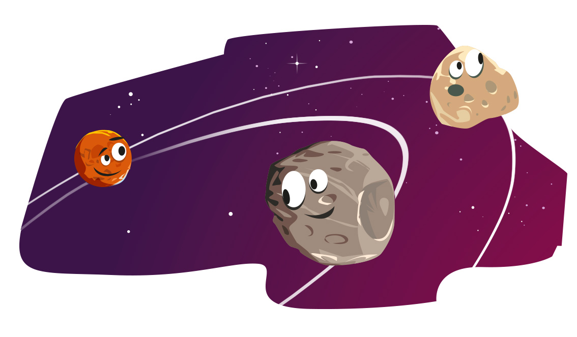
Phobos and Deimos (© Arteclic)
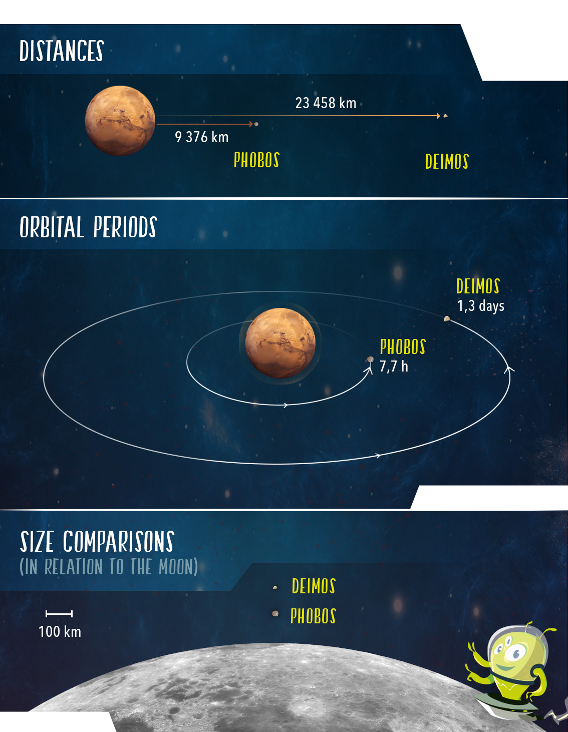
Phobos and Deimos are the two natural satellites, or moons, of Mars. Nowadays, they are in synchronous orbit around Mars, i.e. they take the same time to orbit Mars as to rotate on their own axis. As a result, just like the Earth’s Moon, it is always the same face of each that is visible from the surface of the planet. However, there is a significant difference between these two moons. Phobos, the nearest moon, is slowly getting closer to Mars at a rate of 1.8 meters per century whereas Deimos is slowly moving away from it.
Below, explore the 2 Moons of Mars.
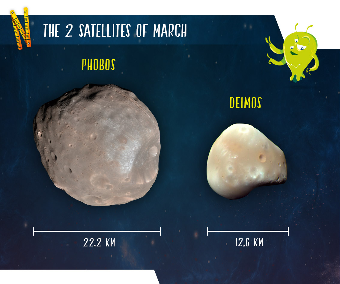
Appearance of Phobos and Deimos (© Arteclic)
Comparison of the 2 satellites of Mars (© Arteclic)
The origin of the Earth’s Moon is explained by a collision theory . A planet named Theia, similar in size to Mars, struck Earth causing a gigantic cataclysm and giving birth to the Moon.
It seems that the moons of Mars, Phobos and Deimos, could have had a similar beginning. They are believed to have been created about 800 million years after the beginning of the formation of Mars, as a result of a collision with a planet three times smaller than Mars.
The debris from this collision would have created an enormous disk around Mars, consisting of a dense internal part, composed of molten material, and a very fine outer part, mostly gaseous.
In the inner part of this disc a moon, 1000 times more massive than Phobos, would have developed, this has now disappeared. Gravitational disturbances created in the outer disk by this massive object would have started the assembly of debris to form other smaller moons further afield.
After a few thousand years, the planet Mars would have found itself surrounded by 10 small satellites and one huge moon. Several million years later, once the debris disk had dissipated, the tidal effects of Mars would have brought back to the planet most of these satellites, including the very large moon. Only the two most distant little moons, Phobos and Deimos, remain.
The formation of the moons of Mars by collision (© LabEx UnivEarthS)
A time lapse video of part of the orbit of Phobos around Mars. Images Captured by the Hubble Telescope.
Phobos around Mars, Hubble Telescope (© NASA)
Here is a presentation showing Phobos and Deimos (Images Captured by the Hubble Telescope).
Views of the moons of Mars ((© Dreksler Astral)
Quiz!
Validate your knowledge!
The internal structure of Mars
 Overview of the interior of Mars
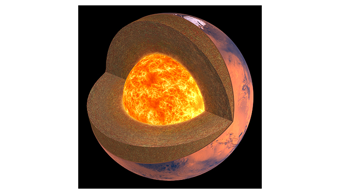
The internal structure of Mars resembles that of the Earth and the Moon: a crust on a silicate mantle and in its center a partially liquid core composed of sulphur, iron, and nickel.
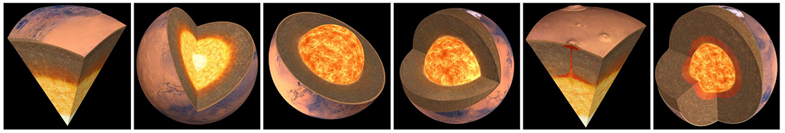
Images of the Martian interior (© IPGP/David Ducros)
The best sources of information come from scientific measurements made on the moment of inertia, gravity, magnetism and from rock sampling, etc.
Measurements of mass and diameter make it possible to calculate the density and the moment of inertia of Mars which gives us an indication of the distribution of mass inside the planet.
Measurements of the gravity field on Mars by satellites confirm that it has a similar layered structure to the Earth, and also provide estimates of the average thickness of the crust.
Meteorites from Mars provide information on the elemental composition of the crust and mantle. Geochemical measurements provide information on the composition of the crust, mantle and atmosphere
To study the interior structure of a planet you need seismic data. Without this, it is difficult to describe the internal structure of Mars.
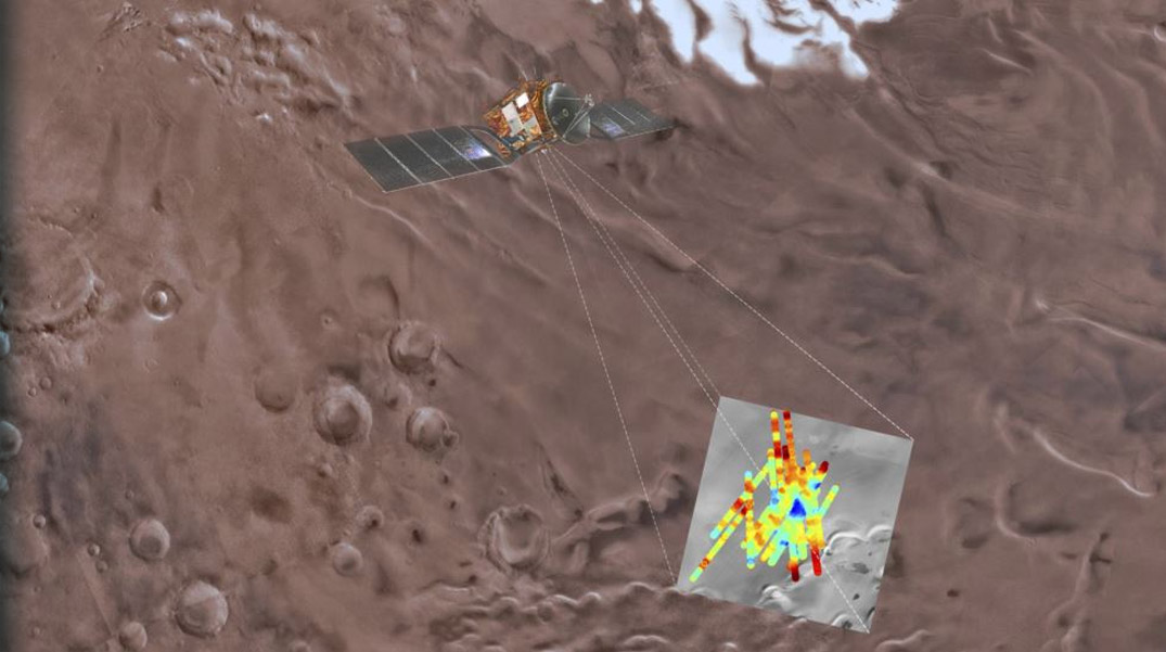
The use of seismic data recorded by the SEIS seismometer allows us to determine first results presented below.
This presentation helps us understand how the measurements are carried out by the SEIS system.
The InSight probe, its SEIS seismometer and how it operates(© CNES).
The first marsquakes reveal that the structure of Mars is more like the Moon than Earth!The SEIS seismometer recorded its first marsquake on the 128th Martian day, that is on April 6, 2019, and since then researchers have recorded dozens of others.
It was a surprise for scientists to discover a very different image from what they had imagined for the red planet!
Up until now they had thought that the Martian crust was similar to the earth’s crust. But quakes on Mars are more like moonquakes than earthquakes. This result means that probably the crust of Mars is drier than expected!
Earthquakes on Earth occur on faults created by the movement of tectonic plates. The seismic waves emitted during these earthquakes travel on different paths, and at different speeds, depending on the type of material they pass through. On Earth, the source of seismic waves is easily detectable, as the Earth’s crust is made up of relatively uniform solid rocks. These rocks contain water, which absorbs energy, causing the waves to rapidly attenuate or lose energy. This is why earthquakes on Earth last only a few minutes.
So what are the quakes on the Moon and Mars caused by since these two planets do not have tectonic plates?
On the Moon, a moonquake is created in a few moments, then the seismic waves propagate and slowly weaken for at least an hour because the material of the Moon is very dry, without water, and very fractured.
On Mars, marsquakes are caused by the long process of cooling and contraction that occurs inside rocky planets. When the core cools, it contracts, which has the effect of causing stress. Over time, this process ends up cracking the crust and causing marsquakes.
According to observations, marsquakes last for 10 to 20 minutes, somewhere between the duration of a moonquake (about 1hr:30) and that of an earthquake (at most a few minutes).
These results indicate that the crust of Mars could be composed of layers of rough, dry and broken rocks, like those of the Moon.
Propagation of seismic waves in the interior of Mars.(© ETH Z)
This artist's impression shows how the seismic waves from a marsquake might travel inside the red planet.(© NASA/ETH Z)
The crust of Mars from geophysical dataThe animation below represents a section of the crust of Mars.
Surface topographic features with their corresponding crustal thickness (© NASA/SVS).
In the animation below, topographic and gravitational data have been combined.
Here, the topographic and gravitational data have been combined. Blues indicate thin areas of the crust, while red and white indicate thicker areas. The slight ripples that appear on the surface are digital artifacts resulting from the process of creating the map. (© NASA/SVS)
These representations of the Martian crust show that the asymmetry of the planet seen between the northern and southern regions is also found below the surface.
In the south and under the volcanic province of Tharsis, the crust is 80 kilometres thick and thins gradually towards the north. On the other hand, in the north and under the southern uplands of Terra d’Arabia, the crust has a more uniform thickness of about 35 kilometres.
This marked asymmetry of the crust suggests that the planet did not cool uniformly
The Mantle of Mars from geophysical dataThe mantle is located between the crust and the core. It serves as a heat exchanger between the core and the outside of the planet. It influences the planetary magnetic field, and plays a major role in the evolution of a planet.
While warming, the mantle rock material produces fluids that rise into the crust and seep to the surface. This is where volcanic phenomena emerge that release elements including carbon and oxygen that affect the climate and all living things.
Movement of mantle rock material (© IPGP/David Ducros)
The Martian mantle probably has a composition similar to that of the Earth. The composition of Martian meteorites indicates that it consists of olivine-rich rocks, silicates, and iron-rich rocks such as peridotites. Its exact composition and structure are not yet known.
The Core of Mars from geophysical dataThe size of the core
The exact size of the core (around 1700 km) is unknown, but it is proportionately smaller than that of the Earth.
This difference in size depends on the conditions in which the planet was formed, especially the differentiation phase. Some of the iron would have remained in the mantle, embedded in iron-rich minerals instead of joining the core.
Internal structure of Mars (© IPGP/David Ducros)
What is the composition of the core ?
Meteorites from the asteroid belt show that planetary cores are mainly formed of iron and nickel.
Analysis of meteorites originating from Mars indicate the presence of sulphur in the Martian core in larger quantities than the Earth’s. The more sulphur there is, the more the core will remain liquid, even at a lower temperature.
On a planet, the state of the core may or may not cause convection motions which generate a magnetic field.
For convection to begin, heat must rise from the core to the surface, passing through the mantle. When the mantle forms an insulating layer and stops this active heat transfer, the core can no longer dissipate its own heat and in this case the convection motions which stir the molten metal in the core stop.
Today, we see that Mars no longer has a global magnetic field.
Does this observation mean that the core of Mars has solidified?
However, if the core of Mars was solid, the planet’s gravitational field would be very different.
Given these 2 observations, scientists believe that part of the nucleus of Mars is still liquid.
What is the role of eth magnetic field ?The presence and funtion of Earth’s magnetic field
The Earth has a magnetic field which protects it from the solar winds. Thanks to this magnetic field on Earth, compasses indicate the direction of North and South.
A compass indicates magnetic north which on Earth is very close to geographic north.
The Earth’s magnetic field, also called our terrestrial shield, is present in space around the Earth as well as in its crust and mantle. About 99% of this magnetic field is generated by the convection movements of liquid iron inside the Earth’s core.
A small part of this field comes from other sources such as: magnetic rocks of the crust, electric currents flowing in the subsoil and electric currents flowing in the ionized layers of the atmosphere.

The global magnetic field facing the solar wind for Mars and the Earth (© NASA/GSFC)
This global magnetic field protects the Earth from particles propelled by solar winds.
The direction and intensity of the Earth’s magnetic field is recorded in the fabric of the rocks formed as mantle material reaches the surface of the Earth. In the mantle, the temperature is too high, and the magma can not be magnetized. However, when this magma reaches the surface, it suddenly cools and is magnetised in the direction of the Earth’s magnetic field at that time. The rocks then keep a memory of the orientation of the Earth’s magnetic field present at that moment when they cooled.
On Earth, the dominant direction of this field switches over time, the North pole becomes the South pole and vice versa. The last switch occurred 780 000 years ago.
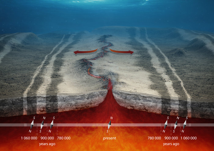
How magnetism is recorded in the earth's crust (© ESA/AOES Medialab)
The presence and function of the Martian magnetic field
Currently it is impossible to orient yourself using a compass and find the North Pole and the South Pole on Mars, which proves that there is no longer a global magnetic field on the red planet.
Effectively there is no longer a magnetic field on the surface of Mars. In other words, there is no longer an electromagnetic shield to ensure the protection of the red planet against radiation from space. The surface of Mars is constantly bombarded by this radiation.
However it is possible to detect the trace of the magnetic field that existed at the beginning of the formation of Mars!
In the past, the Martian crust became strongly magnetized. The high concentrations of iron in Martian rocks allowed the formation of minerals such as hematite and magnetite, and these rocks recorded the presence of a magnetic field on Mars.
It was 30 times more powerful than that of Earth. This indicates that Mars had an internal magnetic field strong enough to magnetise the rocks on its surface. It is almost certain that a molten iron core formed 4.6 billion years ago, in the centre of Mars, and for a few hundred million years up to 4 billion years ago, a magnetic field was produced by the convection motions in this core. This active magnetic field then disappeared, leaving a “fossilised” magnetic field.
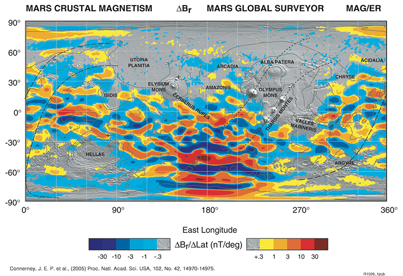
When a rock formation cools, it magnetises, taking the orientation of the Martian magnetic field. This map represents the fossil magnetic field resulting from this process. Maven Mission (© NASA/Goddard)
From this data, scientists discovered that the planet Mars experienced plate tectonics from its formation period up until 4 billion years ago.
In the video below, discover the Maven mission: The first magnetometer to orbit Mars.
The first magnetometer to orbit Mars (© NASA/SVS)
Quiz!
Validate your knowledge!
Climate and water on Mars, is life possible ?
 Mars, a cold and inhospitable world
About 4 billion years ago, wrapped in a thick, dense atmosphere, the young Mars had a warm, wet surface with oceans and lakes. A real little blue planet! This liquid water made the planet potentially habitable and conditions were favorable for life. Gradually its destiny has shifted to become the red and cold planet that we observe today.
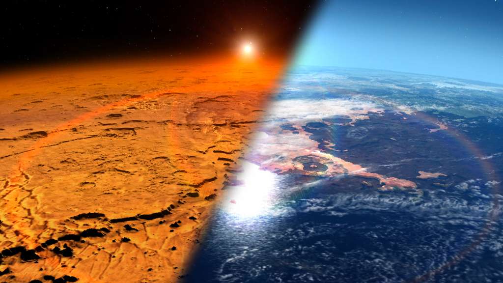
Gradually losing its once dense atmosphere, Mars has become a cold and desert planet (left) while once it was hot and wet (© NASA/JPL)
To understand this radical change, NASA launched the Maven probe in 2013. These studies show that progressively Mars has lost much of its atmosphere due to the action of the solar wind!
Simulation of the loss of Mars atmosphere due to solar winds (© NASA Maven mission)
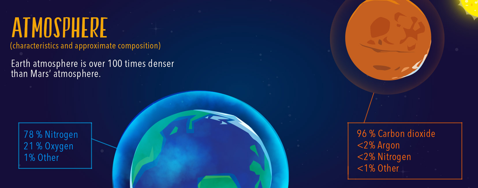
Today, Mars has almost no atmosphere and its air is unbreathable. It is composed of 96% Co2 (on the Earth, about 1%), 1.93% argon, 1.89% nitrogen (on Earth, about 78%) and contains traces of O2 (on Earth, about 21%), water, and methane.
The Martian atmosphere has become very thin, the atmospheric pressure on the surface of Mars is 100 times less than on Earth.
The biggest consequence of this change is that the Martian atmosphere has become incapable of retaining the heat brought to the surface by the Sun. This explains why the surface of Mars is frozen, why the temperature variations between the day and the night are so significant and finally why the variations of temperature with altitude are so great.
What is the temperature on Mars ? Today it is cold on Mars, very cold, and the temperature fluctuations are very large (@ NASA/JPL)
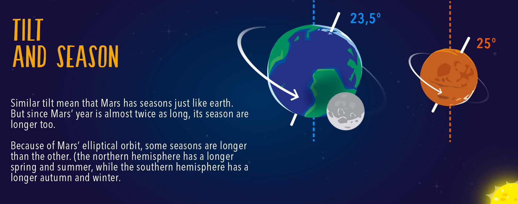
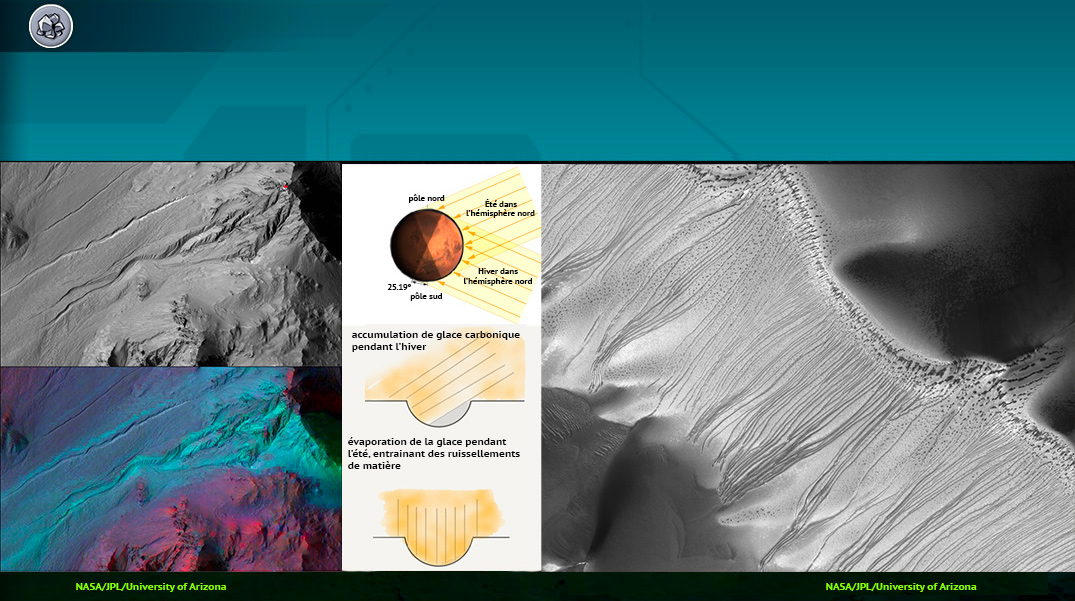
What is the climate on Mars?On Mars, as on Earth, the existence of seasons is linked to the tilt of the axis of rotation at an angle of 25.19° relative to the vertical axis.
Because of this tilt, the length of the day changes during the year. The orientation of the Martian surface with respect to the Sun’s rays is not always the same throughout the year. In summer a maximum amount of energy is received while in winter it is a minimum amount.
On Mars, the seasons do not all have the same durations. To understand this phenomenon watch, on the animation below, how a year passes on Mars.
What is the duration of a year on Mars? (@ NASA/JPL)
Compare below the duration of the 4 seasons between the northern hemisphere and the southern hemisphere of Mars.
| In the northern hemisphere | In the southern hemisphere |
|---|---|
|
|
The succession of these four seasons causes important climatic changes on the surface of Mars.
What are these main changes?
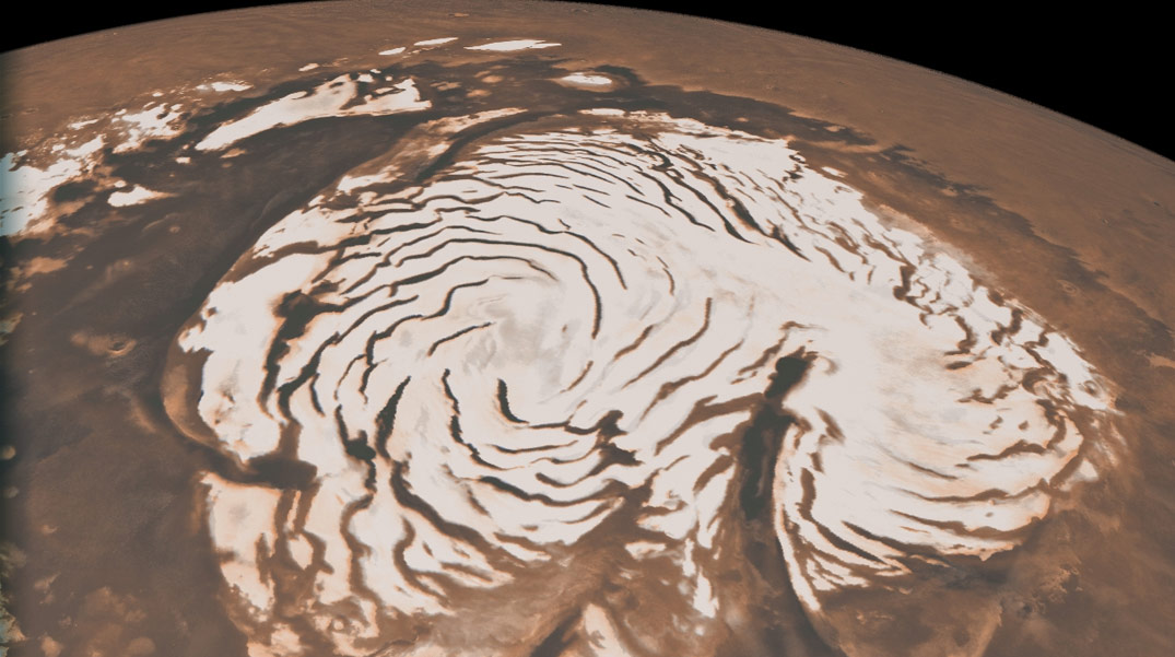
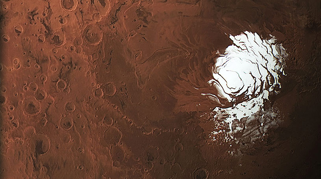
The polar caps
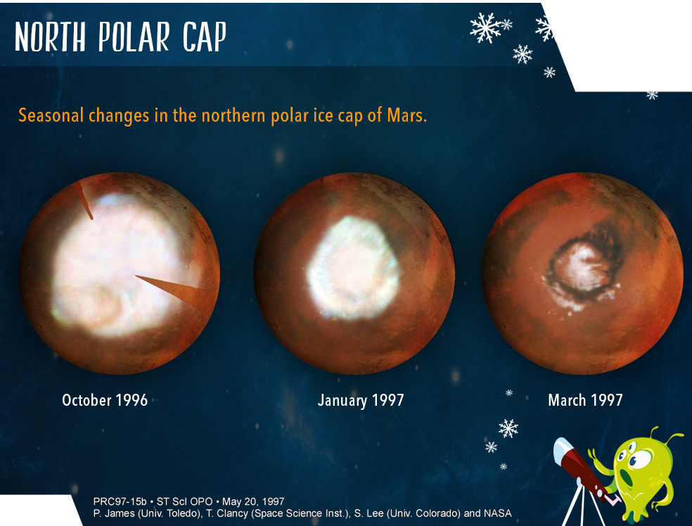
Polar cap in the northern hemisphere (@ NASA/Hubble Space Telescope)
Mars has polar ice caps, at its north pole and its south pole, consisting of water ice. During part of the Martian year, frozen CO2 covers them. In the summer, some of this solid CO2 enters the gaseous state in the atmosphere (a process called sublimation), causing significant variations in pressure and atmospheric composition. In winter, nearly 25% of the CO2 in the atmosphere condenses into solid CO2 that covers the ice sheets forming these polar ice caps.
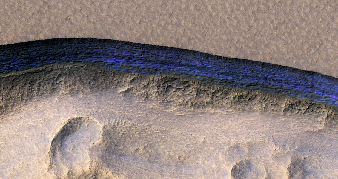
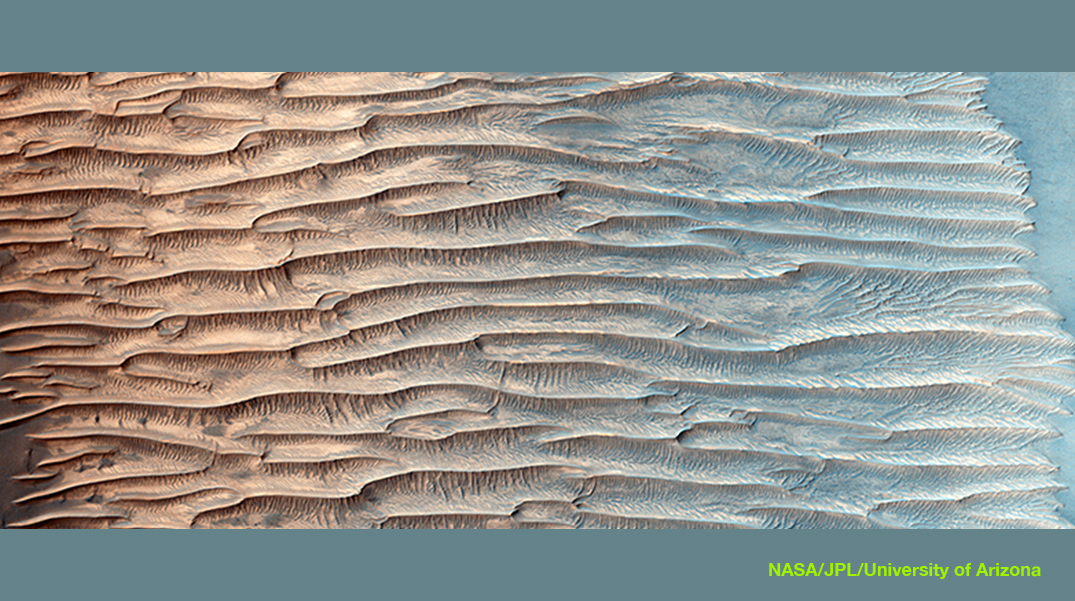
The various layers of ice (false blue color) accumulated are clearly visible on the walls of the cliffs. They indicate the presence of ice under the surface of Mars (@ NASA/JPL/Univeristy of Arizona).
Winds and cyclonic storms
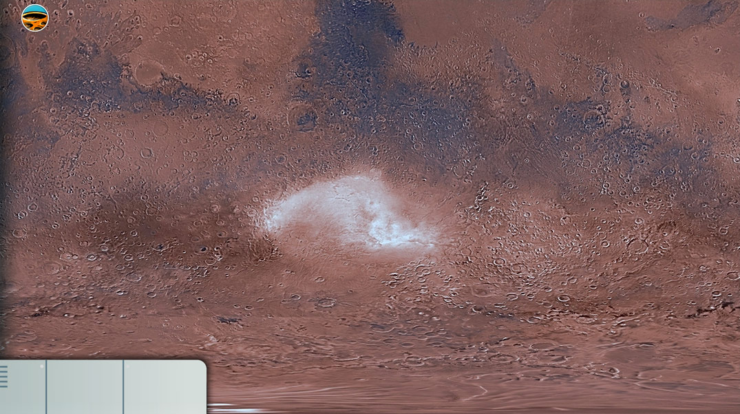
Since CO2 sublimates into the atmosphere during the Martian summer, it leaves behind traces of water. Seasonal winds blow at the poles at speeds approaching 200 km/h and carry away large amounts of dust and water vapour giving rise to cirrus clouds.
In the spring and summer, these variations of CO2 in the atmosphere give rise to gigantic dust storms that can cover the whole surface of Mars. Martian winds, capable of raising sand or frost storms, do not blow as strongly as on Earth due to the lower atmospheric pressure and the low density of the planet. These winds do not exceed 80km/h. These swirls of dust have a spiral shape when they rise 15 to 30 km above a volcano. They are present throughout the Martian year, with a peak at the end of the summer.
During these sandstorms the atmosphere is filled with clay particles that give the sky a rusty color.
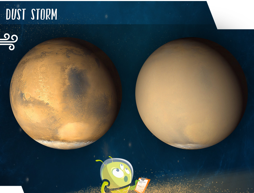
Storm of sand or dust.On the left, a view of Mars at the end of June 2001 shows clear conditions over a large part of the planet. July 2001 image shows the planet almost completely enveloped in dust.
Cyclonic storms similar to cyclones on Earth have been detected during the summer in the northern hemisphere and only at high latitudes. The images are white in color, unlike sandstorms.
InSight records wind noise on Mars (@ NASA/JPL)
Water has shaped the landscapes of MarsDespite the largely unfavourable atmospheric pressure and temperature conditions, the presence of liquid water on Mars is shown by numerous observations such as the presence of hydrated minerals (for example Zircon) and ancient valleys and channel systems.
All this geological evidence shows that the activity of water on Mars lasted for a period going from 4.5 to 3 billion years ago.
Then, Mars would have experienced an episode of global climate change, leading to the cold and arid conditions we see today.
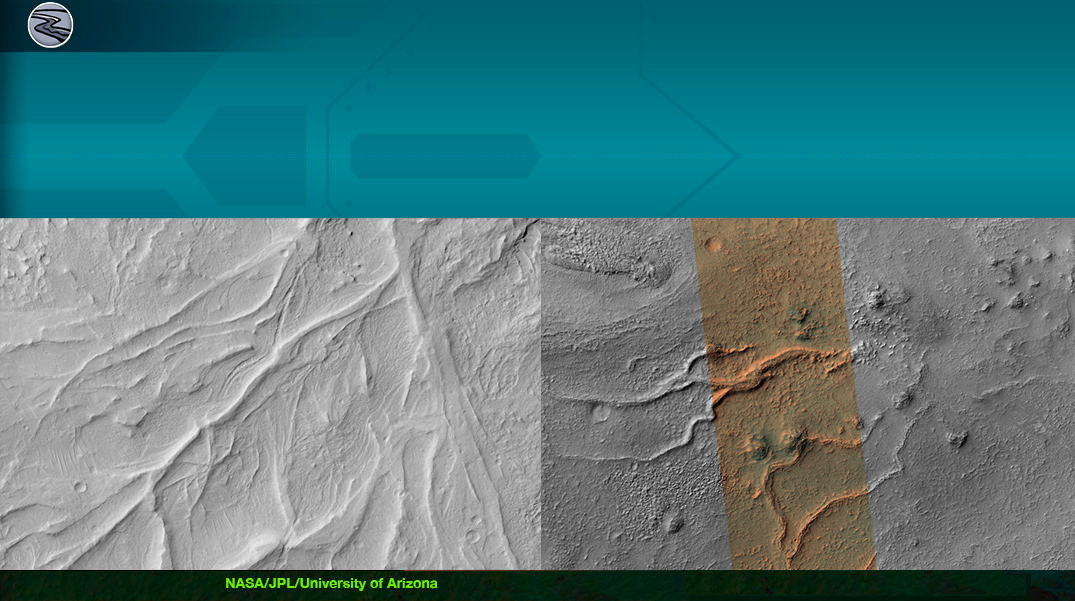
Use the map below to discover the most significant geological evidence that shows the presence of water, wind, CO2 ice, and ice water on the surface of Mars.
Phoenix provided climate data: cloud formation and movement, fog, dust storms and surface wind speed. Each spring, much of the polar ice changes into ice clouds.
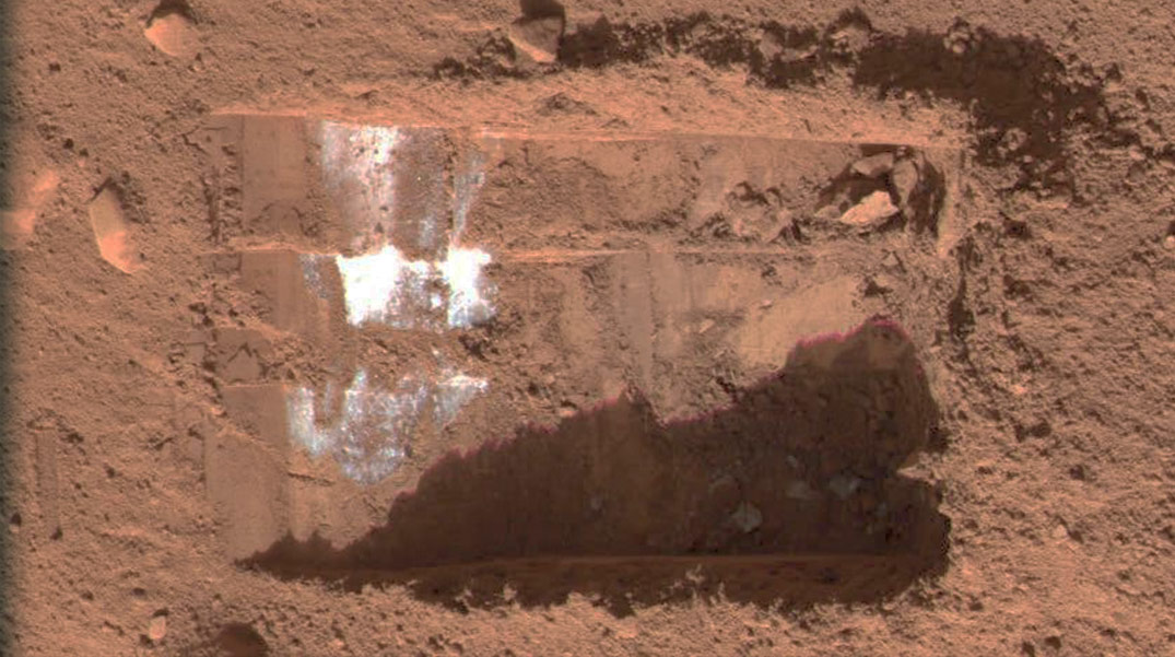
On July 31, 2008, frozen water was detected in the Martian ground of the North Pole by analyzing the vapors released by the melting of the ice.
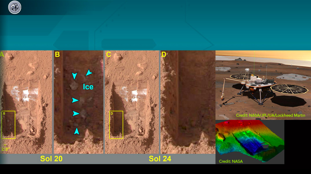
Below, the seasonal ice has almost melted. For hundreds of kilometres around, there are only bumps and hollows about 1 m high and 20 m wide. Under the ice, the layers of deposits contain rock fragments that formed a large polar dune before the ice settled.
On a larger scale, gigantic spiral pits can be seen from the centre of the pole. They reflect the influence of the Coriolis force on the winds in the region from the formation of the ice cap to the present day. As the superimposed deposits of materials increased, so did the landforms and the ditches between them.
The impact craters that form in this region undergo different modification processes than those that form in more equatorial areas. For example: Most of the materials that make up an ice crater are volatile, that is, they can sublimate (move directly from a solid to a gas) if heated.
Sublimation is on Mars because of its very thin atmosphere. On Mars, the seasonal ice that settles at high altitudes in winter and melts in spring is CO2 ice.
The circular spot of shiny material in the centre of the crater is not CO2 ice, but water ice. During the summer in the northern Martian hemisphere, the CO2 ice present in the region sublimated. On the contrary, water ice is present all year round, because temperature and pressure conditions do not favour its sublimation.
The 200 metres of ice height also includes sand dunes. Small traces of water ice are visible along the crater walls. The lack of ice along the northwestern edge is due to the fact that this area remains heated by the Sun’s rays.
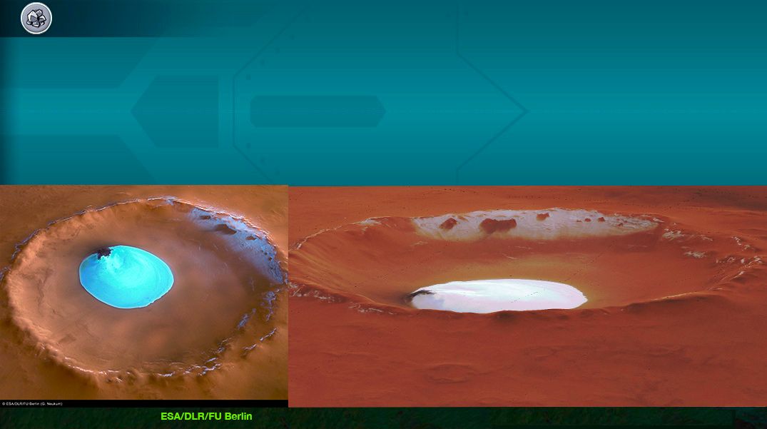
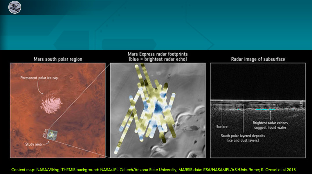
Most of the Martian water exists as ground ice. The presence of ejection and flow channels around the crater suggests that the primary impact penetrated the surface and melted a buried frozen water reservoir.
Radar pulses do not reach the bottom of this tank. It is impossible to know if the water body at a depth greater than 2m. The water is at about -68°C. It remains liquid because it is under pressure and rich in magnesium, calcium and sodium.
This discovery increases the probability that a microbial life that appeared on Mars could continue to lead an existence below the Earth’s surface. The challenge for any Martian microbe is to adapt to saline conditions without drying out.
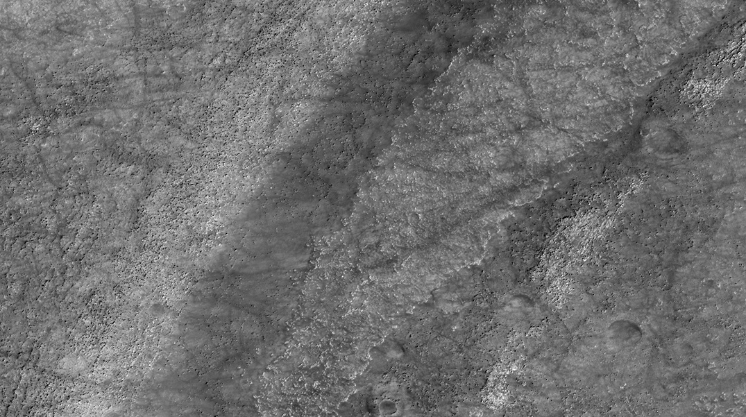
The Kasei Valles flow system is the largest magmatic flow system on Mars.
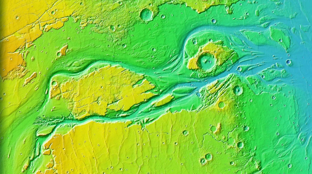
The old river channels are made of coarse gravel. Meanders formed when a stream gradually eroded the outer banks.
The river cut through the meanders creating arched lakes. The CRISM instrument on board the Mars reconnaissance orbiter has detected clays that prove the presence of water on Mars.
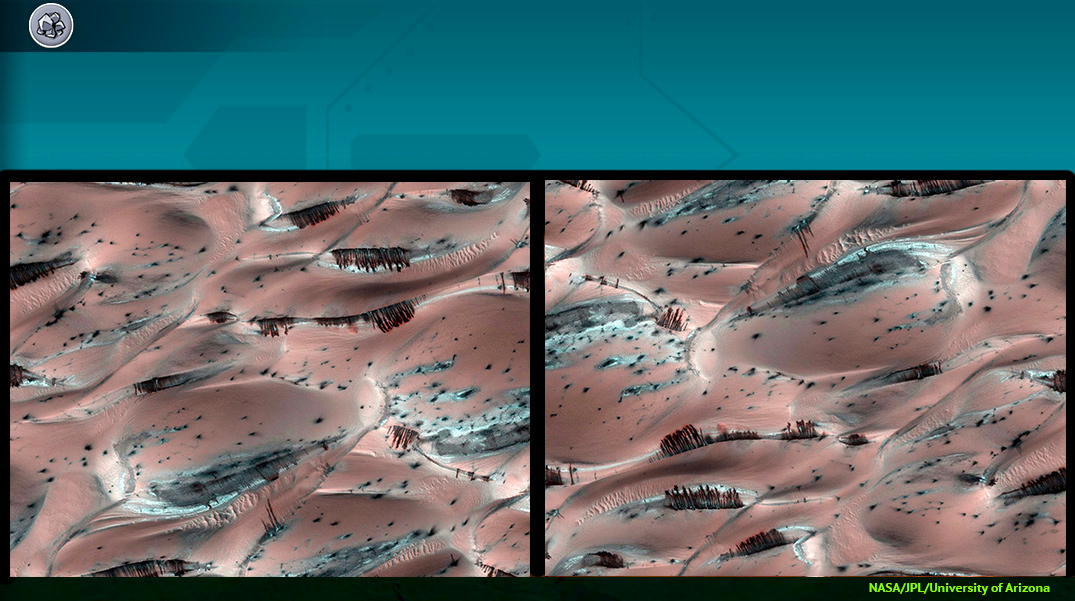
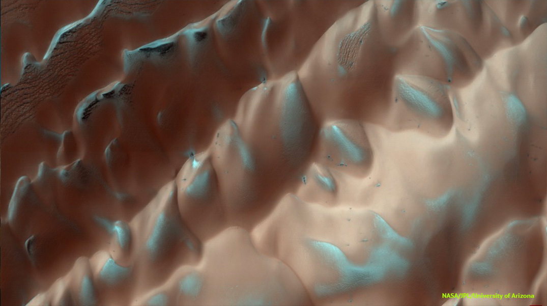
Martian cones have a diameter ranging from 30 to 1000 m and are located in the northern volcanic plains.
This photo is Amazonis Planitia, a vast area covered by lava. Its surface is covered with a thin layer of reddish dust.
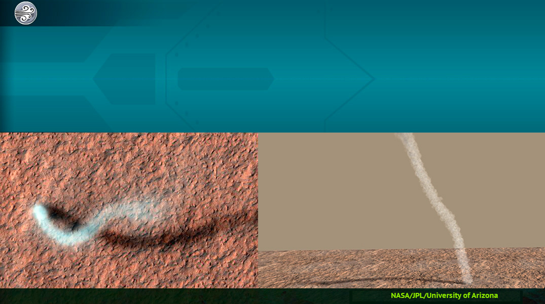
On the left, a whirlwind of dust on the Amazonis Planitia. It was taken by the Mars reconnaissance probe in orbit around Mars.
On the right, a reconstruction of3 this whirlwind of dust from the surface. It was 30 metres wide and 800 metres high.
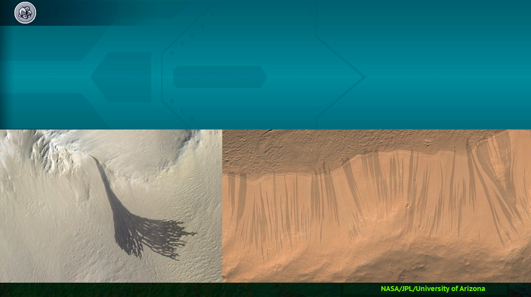
When a pole is exposed to the sun’s rays, its ice cap melts, causing an increase in temperature, pressure and humidity. Moisture then accumulates as dry ice in mid-latitudes, particularly on pole-facing slopes because the poles are more shaded.
Then, the sun’s rays make the CO2 ice sublimate, creating gullies. At higher altitudes, the atmosphere is very thin. There is no ravine because the CO2 ice is sublimated.
Discovered through photos of the Viking orbiter, the stripe bands could be studied more seriously through high quality photos from Mars Global Surveyor and Mars Reconnaissance Orbiter. The exact cause of these striae is not known.
They would be formed by the flow of brackish water during the Martian summer. They are often diverted by the terrain they cross. In the picture on the left, the stripe split into several small striae when it encountered obstacles.
On the left, the dunes of the North Pole are snow-covered. Dark lines are the underlying layers of darker rocks that are highlighted when CO2 ice pushes the surface layers down.
The flow of water carries the material away and redeposits it further. Large rocks are deposited first, and small sediments, such as small stones or sand, are deposited further from the source. When the glacier retreats, there is still a pile of debris.
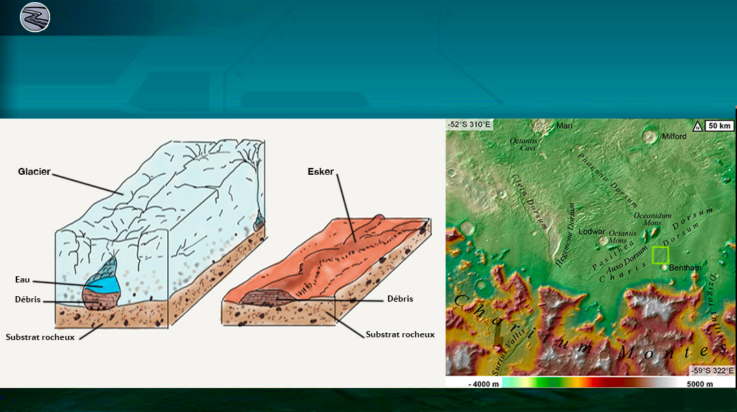
Solidification of the channel bed can have several causes: it can be covered with lava, cemented by reacting with the elements in the water, or larger rocks have remained in place while the fine materials have been carried away by the wind.
Whatever their origin, these reliefs provide important information about Mars’ past.
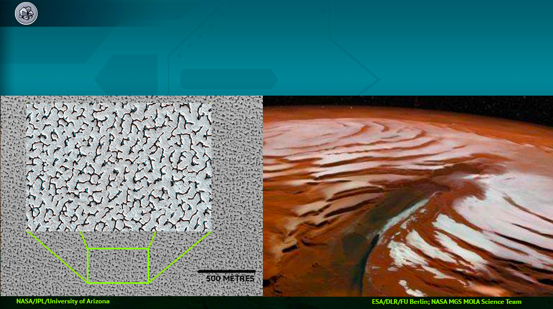
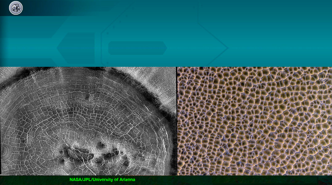
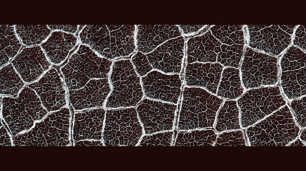
Scientists study polygonal soils on Mars because the presence and physical characteristics of polygons help us understand the recent and past distribution of ice just below the surface. These characteristics also provide clues to climatic conditions.
Other polygons (right image) are formed by the intersection of the ridges of the sand dunes. If these structures solidify and erode, it will be difficult to say that they come from windblown dunes and not from the bottom of a dry lake. Crater bottoms are good places for dune accumulation but also a good place for a temporary lake.
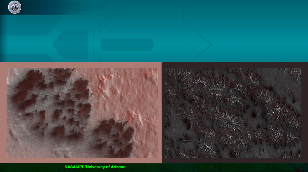
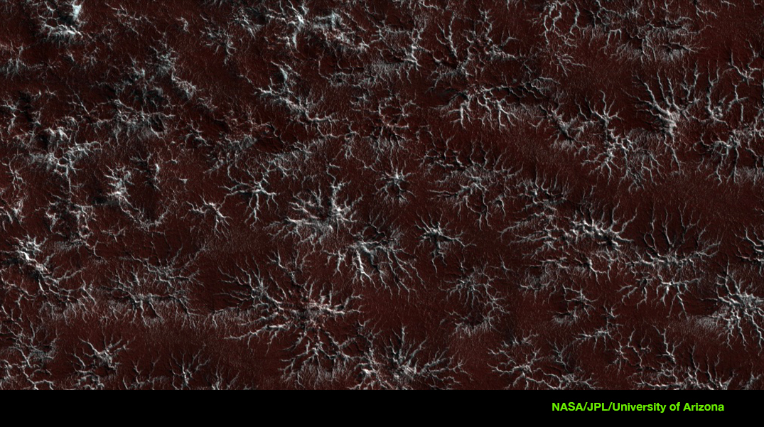
Each spring, the seasonal sublimation of the South Pole ice cap erodes the landscape into beautiful terrain. These recessed patterns form patterns called spiders or stars. Their origin is still unknown.
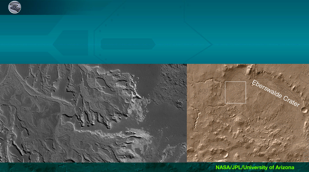
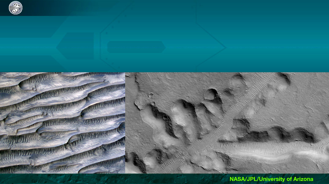
Sometimes, TARs have secondary structures, small undulations, often with different orientations that can be shaped by winds redirected by large dunes. On the left photo, the secondary structures have an unusual radiant/convergent structure, which gives the TARs a feathery appearance. The photo on the right shows the TARs in Nirgal Vallis, one of the longest valley networks on Mars (about 400 kilometres long).
Although it was formed a long time ago, probably by running water, abundant wind-blown sediments have transformed the valley floor into dune fields. These forms are stable over time, so they either form slowly on long time scales or they have formed in the past when atmospheric conditions were different.
*The example of Mars is interesting because liquid water existed on its surface at the beginning of its history, before disappearing rather quickly: what could explain why this evolution is so different from the history of the Earth? *
Disappearance of water on Mars: is it just too small?
A hypothesis that has been proposed is the importance of the role played by the small size of Mars in this phenomenon. The low level of Martian gravity could not retain the nitrogen present in its atmosphere, which has subsequently escaped. Being small, Mars quickly lost its internal energy and while cooling, its initially liquid core became solid.
This mechanism has had two consequences:
Firstly the disappearance of the Martian magnetic field so that it no longer protected the surface of Mars from solar winds, causing the dissipation of the Martian atmosphere into interstellar space.
In addition, volcanism decreased. This volcanism had previously released a large amount of CO2 into the atmosphere.
Finally, once the N2 had escaped into space, only CO2 remained in the atmosphere. This CO2 tends to dissolve in water and settle to the bottom of bodies of water in the form of carbonates, leading to a decrease in atmospheric pressure.
Evaporation of Martian water
Once the atmospheric layer had thinned enough, solar radiation could easily reach the Martian surface. This radiation was able to break down water molecules present in the upper atmosphere and expel them permanently into interstellar space.
Thus, Mars lost much of its water.
Today, a little water is preserved in the form of ice on the Martian surface at the latitides of the polar caps but this quantity is tiny in comparison to the quantity of water which flowed on the surface of Martian at the beginning of its history.
Is it possible that there is life on Mars ?The investigations of Curiosity, Spirit, Opportunity as well as the observations of several orbiters, show that there have been 4 billion years of conditions favorable to the birth of life on the surface of Mars..
But perhaps these beginnings were too fleeting for life to have had time to fully develop ?
On the other hand, in the subsoil, microscopic organisms may have found the necessary conditions to develop for millions of years.
Indeed, scientists suspect that lakes of liquid water exist below the Martian surface and although the water is very salty, bacterial life could thrive there.
To know if this form of life could exist, robots like ExoMars 2020 (ESA) and Mars 2020 (Nasa) are going to explore Mars and lead the investigation. In 2021 the first returns from these exciting investigations should be released!
Mars 2020 rover to take soil samples for analysis.(© NASA/JPL)
Plans for a manned mission to Mars !NASA has unveiled plans for the human exploration of the Moon and the Martian system. It published the schedule of assembly and logistics missions as well as that of manned missions. Final goal: to go to Mars during the 2030s !
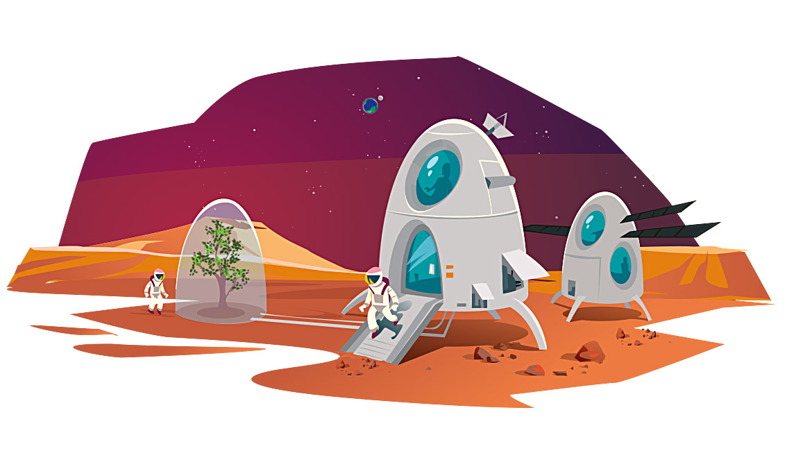
NASA sets a target of 2033 to send the first humans to Mars.(© Arteclick)
NASA wants to send men to Mars via the moon. In 2024 its goal is the Moon!
NASA is starting to learn how to extract and exploit the tons of ice at the South Pole of the Moon. Water ice can give air to breathe, water to drink and fuel. Its goal is not only to bring humans back to the lunar surface but to prove that men can work and live on another world.
A long way from the 3 days it takes to go to the moon, a mission to Mars lasts at least 2 years, because of the distance. The one-way trip Earth-Mars lasts 6 months.
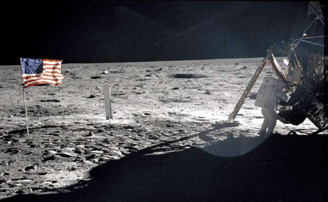
July 1969, first step of the man on the Moon. 50 years later mankind is on its way back to the moon.(© Nasa)
NASA intends that the Moon will serve as a springboard to reach the Red Planet.
For this purpose it has planned a number of missions in the lunar environment,including the assembly of a gateway to deep space (Deep Space Gateway). This will require 4 missions and the construction, in orbit, of a transport system for deep space. The transport system is a 41-tonne vehicle that will be used to travel back and forth to Mars. It is big enough for 3 Martian missions and will support, for each mission, a crew of four astronauts for 1,000 days.
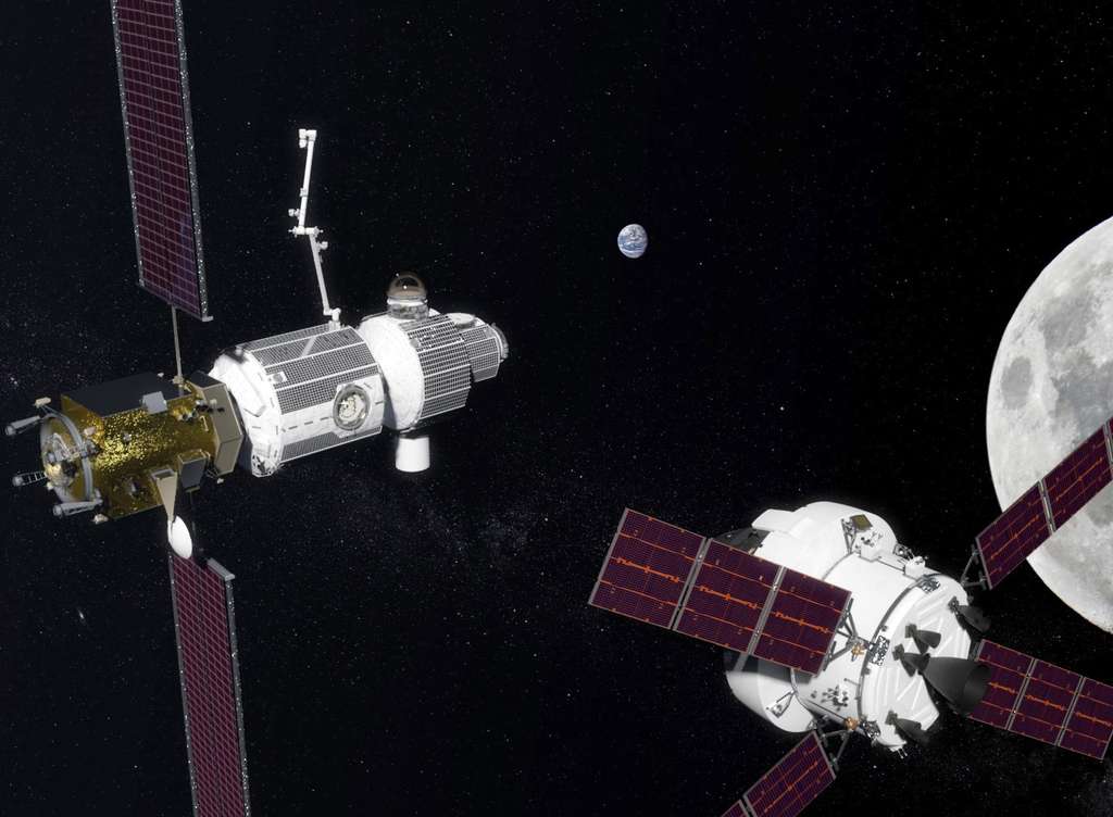
The Deep Space Gateway is a space station project close to the Moon.(© Nasa)
This gateway to deep space is the central element of NASA’s lunar strategy. It is the orbital structure that will succeed the International Space Station (ISS).
5 phases to take NASA and its partners to Mars :
Phase 1: Use of the International Space Station as a test bench and inventory of available lunar resources that can be exploited and used for subsequent stages of exploration.
Phase 2: missions and human activities near and around the Moon. Beginning of the assembly of the Deep Space Gateway and the transport system for deep space.
Phase 3: end of the construction of the transport system for deep space and conducting the first Martian test missions, (these will be carried out near the Moon).
Phases 4 and 5: first missions to the Martian system and the surface of Mars. Phobos, one of the 2 martian moons could be the first destination.
*The environmental conditions on Mars are a real challenge for mankind! *
The will is present !
Our hope is allowed !
Quiz!
Validate your knowledge!
Game
MarsWith Marsty collecting Martian samples !

Game
Previous adventure
End of mission

Next adventure
We would like to thank :
Paul Denton
Denton Seismo Ltd UK,www.dentonseismo.co.uk
English translation
Serge Monnier
Aggregate of Philosophy
Proofreading
Jeanne-Thalie Deprince
Images, animations
Laurence Laffargue-Rieder
German translation
Philippe Labrot
IPGP, Institut de Physique du Globe de Paris, France
Scientific Interaction
Philippe Lognonné
IPGP, Institut de Physique du Globe de Paris, France
Scientific Interaction
Philippe Laudet
CNES, National Centre for Space Studies, France
Scientific Interaction
William Bruce Banerdt
JPL, Jet Propulsion Laboratory, Pasadena, CA, USA
Scientific Interaction
Credits : IPGP, NASA, JPL, CNES, CEA, ETH Zurich and University of Zürich